Where to find Wood Thrush in July
within 25 miles of New York City, United States
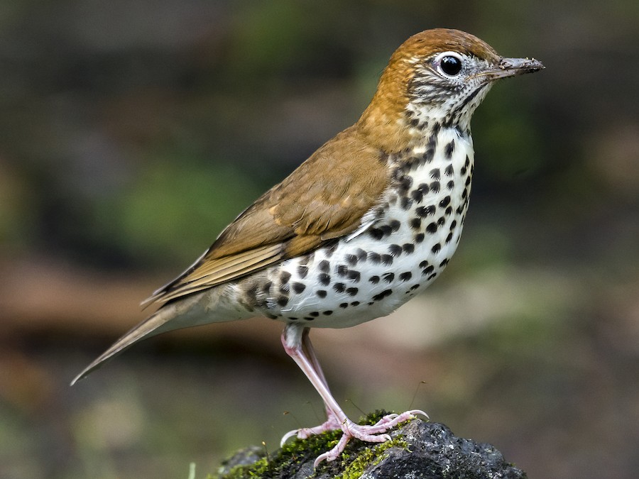
This page shows which locations in the selected region historically had the highest probability of a checklist including Wood Thrush in July. Because some locations may be undersampled, the results are sorted based on a confidence score which takes into account how many samples are available. The bar chart shows how the probability of observing this species varies over the year.
- Click on a month in the bar chart to switch to that month.
- Click on a location to view its top birds.
- Click here to view a map on eBird.
| Evidence | Sampling | Score | ||||||||
|---|---|---|---|---|---|---|---|---|---|---|
| # | Location | Dist | Media | Years | Birders | Hits | Lists | Freq | Conf | |
| 1 | Mayapple Hill | 15.3 | 0 | 4 | 2 | 17 | 19 | 89.5% | 68.6% | |
| 2 | Alley Pond Park--Southern Woodlands | 14.0 | 1 | 3 | 3 | 8 | 8 | 100.0% | 67.6% | |
| 3 | Woodlands School | 24.5 | 0 | 5 | 5 | 28 | 35 | 80.0% | 64.1% | |
| 4 | North Mt. Loretto SF--Reed Marsh | 17.6 | 0 | 4 | 2 | 38 | 54 | 70.4% | 57.2% | |
| 5 | Hillside Woods & Children's Village | 20.7 | 0 | 6 | 7 | 34 | 49 | 69.4% | 55.5% | |
| 6 | Hatfield Swamp IBA--West Essex Park | 18.2 | 1 | 11 | 5 | 69 | 108 | 63.9% | 54.5% | |
| 7 | Alley Pond Park | 14.0 | 1 | 14 | 24 | 61 | 95 | 64.2% | 54.2% | |
| 8 | Kings Point Park | 15.1 | 1 | 8 | 4 | 19 | 26 | 73.1% | 53.9% | |
| 9 | Clay Pit Ponds | 17.0 | 0 | 3 | 8 | 7 | 8 | 87.5% | 52.9% | |
| 10 | Garvies Point Preserve | 21.1 | 1 | 6 | 9 | 19 | 27 | 70.4% | 51.5% | |
| 11 | Sands Point Preserve | 19.0 | 4 | 11 | 20 | 48 | 77 | 62.3% | 51.2% | |
| 12 | Hatfield Swamp IBA--Great Piece Meadow | 20.6 | 0 | 10 | 17 | 38 | 61 | 62.3% | 49.7% | |
| 13 | Watchung Reservation | 19.7 | 0 | 9 | 16 | 29 | 46 | 63.0% | 48.6% | |
| 14 | Demarest Nature Center | 17.3 | 1 | 7 | 7 | 15 | 23 | 65.2% | 44.9% | |
| 15 | Hartshorne Woods | 22.4 | 0 | 13 | 25 | 28 | 48 | 58.3% | 44.3% | |
| 16 | North Mt. Loretto SF--Snag Swamp | 17.8 | 0 | 7 | 2 | 28 | 48 | 58.3% | 44.3% | |
| 17 | Frelinghuysen Arboretum | 24.3 | 1 | 10 | 10 | 18 | 29 | 62.1% | 44.0% | |
| 18 | Taylor Lake | 17.5 | 1 | 1 | 1 | 3 | 3 | 100.0% | 43.8% | |
| 19 | Tenafly Nature Center | 14.8 | 1 | 8 | 10 | 20 | 33 | 60.6% | 43.7% | |
| 20 | Garret Mountain Reservation (Park) | 15.7 | 7 | 14 | 26 | 87 | 175 | 49.7% | 42.4% | |
| 21 | Mills Reservation | 14.4 | 2 | 6 | 12 | 16 | 28 | 57.1% | 39.1% | |
| 22 | Blue Heron Park | 15.6 | 0 | 7 | 9 | 12 | 20 | 60.0% | 38.7% | |
| 23 | Ridge Road Park | 23.6 | 0 | 1 | 2 | 4 | 5 | 80.0% | 37.6% | |
| 24 | Inwood Hill Park | 11.7 | 8 | 12 | 59 | 280 | 700 | 40.0% | 36.4% | |
| 25 | Inwood Hill Park--Shorakkopoch Rock | 11.8 | 0 | 3 | 4 | 5 | 7 | 71.4% | 35.9% | |
| 26 | High Mountain Preserve | 20.5 | 0 | 4 | 4 | 9 | 15 | 60.0% | 35.7% | |
| 27 | Rockleigh Woods Sanctuary & Lamont Reserve | 20.4 | 1 | 4 | 5 | 9 | 15 | 60.0% | 35.7% | |
| 28 | Cunningham Park | 12.6 | 0 | 6 | 4 | 8 | 13 | 61.5% | 35.5% | |
| 29 | Cunningham Park Southeast Preserve | 12.4 | 0 | 3 | 5 | 6 | 9 | 66.7% | 35.4% | |
| 30 | Hilltop Reservation | 15.8 | 2 | 7 | 12 | 17 | 33 | 51.5% | 35.2% | |
| 31 | Todt Hill Woodlands | 10.1 | 0 | 2 | 2 | 2 | 2 | 100.0% | 34.2% | |
| 32 | High Rock Park | 10.9 | 0 | 9 | 10 | 15 | 30 | 50.0% | 33.2% | |
| 33 | South Mountain Reservation | 15.5 | 0 | 10 | 18 | 34 | 80 | 42.5% | 32.3% | |
| 34 | Cemetery of the Resurrection--North Overlook | 17.6 | 0 | 5 | 2 | 43 | 109 | 39.4% | 30.8% | |
| 35 | High Rock Park--Moses Mt. | 11.1 | 0 | 2 | 3 | 3 | 4 | 75.0% | 30.1% | |
| 36 | South Mountain Reservation--Wildflower and Forest Preserve | 15.0 | 0 | 2 | 2 | 3 | 4 | 75.0% | 30.1% | |
| 37 | Wolfe's Pond Park--Acme Pond | 16.5 | 0 | 2 | 3 | 4 | 6 | 66.7% | 30.0% | |
| 38 | Clove Lakes Park | 8.6 | 0 | 18 | 4 | 99 | 280 | 35.4% | 30.0% | |
| 39 | Great Swamp NWR | 23.9 | 0 | 20 | 52 | 68 | 189 | 36.0% | 29.5% | |
| 40 | Pelham Bay Park--The Meadow and adj. woodland | 15.0 | 0 | 4 | 5 | 7 | 13 | 53.8% | 29.1% | |
| 41 | Flat Rock Brook Nature Center | 11.4 | 0 | 6 | 9 | 8 | 16 | 50.0% | 28.0% | |
| 42 | Wagner College | 8.3 | 0 | 8 | 1 | 77 | 233 | 33.0% | 27.3% | |
| 43 | Walker Avenue Wetlands | 20.7 | 0 | 11 | 23 | 68 | 206 | 33.0% | 27.0% | |
| 44 | South Mountain Reservation- Crest Drive | 14.7 | 0 | 3 | 5 | 5 | 9 | 55.6% | 26.7% | |
| 45 | Loantaka Brook Reservation | 23.9 | 0 | 10 | 12 | 56 | 170 | 32.9% | 26.3% | |
| 46 | Closter Nature Center | 18.3 | 1 | 6 | 6 | 29 | 81 | 35.8% | 26.2% | |
| 47 | Willowbrook Park | 11.2 | 0 | 5 | 4 | 8 | 17 | 47.1% | 26.2% | |
| 48 | Tatum Park | 23.7 | 0 | 5 | 7 | 6 | 12 | 50.0% | 25.4% | |
| 49 | Watchung Reservation--Deserted Village and Fields | 20.3 | 0 | 2 | 4 | 4 | 7 | 57.1% | 25.0% | |
| 50 | North Mt. Loretto SF | 17.9 | 0 | 3 | 3 | 7 | 15 | 46.7% | 24.8% | |
| 51 | Harts Brook Nature Preserve | 23.3 | 2 | 6 | 5 | 9 | 21 | 42.9% | 24.5% | |
| 52 | Cemetery of the Resurrection | 17.4 | 0 | 5 | 2 | 19 | 53 | 35.8% | 24.3% | |
| 53 | Alonzo F. Bonsal Wildlife Preserve | 13.4 | 0 | 4 | 4 | 13 | 34 | 38.2% | 23.9% | |
| 54 | Christopher Morley County Park | 18.7 | 0 | 2 | 2 | 5 | 10 | 50.0% | 23.7% | |
| 55 | Ash Brook Reservation | 19.7 | 0 | 3 | 2 | 3 | 5 | 60.0% | 23.1% | |
| 56 | Marshlands Conservancy | 22.9 | 1 | 15 | 91 | 140 | 528 | 26.5% | 22.9% | |
| 57 | Eagle Rock Reservation | 13.8 | 1 | 5 | 6 | 6 | 14 | 42.9% | 21.4% | |
| 58 | Van Cortlandt Park--NW Forest | 14.5 | 1 | 3 | 3 | 5 | 11 | 45.5% | 21.3% | |
| 59 | Pelham Bay Park--Hunter Island | 15.9 | 0 | 5 | 11 | 9 | 24 | 37.5% | 21.2% | |
| 60 | Montclair Hawk Watch | 14.2 | 0 | 1 | 1 | 1 | 1 | 100.0% | 20.7% | |
| 61 | Arden Heights Woods | 14.4 | 0 | 1 | 1 | 1 | 1 | 100.0% | 20.7% | |
| 62 | St. Francis Woodlands | 9.8 | 0 | 1 | 1 | 1 | 1 | 100.0% | 20.7% | |
| 63 | Forest Park | 8.1 | 0 | 6 | 7 | 14 | 44 | 31.8% | 20.0% | |
| 64 | Brightwood Park | 19.5 | 0 | 3 | 5 | 6 | 15 | 40.0% | 19.8% | |
| 65 | Twin Lakes Park, Eastchester | 19.4 | 2 | 3 | 3 | 4 | 9 | 44.4% | 18.9% | |
| 66 | Watchung Reservation--Nature and Science Center | 19.3 | 0 | 3 | 3 | 4 | 9 | 44.4% | 18.9% | |
| 67 | Hunt Woods Park | 17.6 | 1 | 2 | 2 | 3 | 6 | 50.0% | 18.8% | |
| 68 | VE Macy Park--Great Hunger Memorial | 23.0 | 0 | 1 | 2 | 3 | 6 | 50.0% | 18.8% | |
| 69 | Troy Meadows Natural Area | 21.1 | 0 | 8 | 10 | 24 | 94 | 25.5% | 17.8% | |
| 70 | Forest Park--Waterhole | 8.7 | 0 | 2 | 3 | 5 | 13 | 38.5% | 17.7% | |
| 71 | Oradell Reservoir and Emerson Woods | 17.7 | 0 | 7 | 8 | 11 | 38 | 28.9% | 17.0% | |
| 72 | Deep Cut Gardens | 23.3 | 0 | 2 | 3 | 4 | 10 | 40.0% | 16.8% | |
| 73 | Welwyn Preserve | 22.5 | 0 | 2 | 2 | 3 | 7 | 42.9% | 15.8% | |
| 74 | Greenbelt Nature Center | 11.1 | 0 | 3 | 2 | 3 | 7 | 42.9% | 15.8% | |
| 75 | Irvington Woods | 23.8 | 0 | 2 | 3 | 3 | 7 | 42.9% | 15.8% | |
| 76 | Watchung Reservation--Lake Surprise | 19.1 | 0 | 3 | 3 | 3 | 7 | 42.9% | 15.8% | |
| 77 | Tackamac Park | 24.3 | 1 | 2 | 1 | 2 | 4 | 50.0% | 15.0% | |
| 78 | Nokia Fitness Trail | 21.3 | 0 | 1 | 1 | 2 | 4 | 50.0% | 15.0% | |
| 79 | Hepburn Woods | 22.4 | 0 | 1 | 1 | 2 | 4 | 50.0% | 15.0% | |
| 80 | South Mountain Reservation--Southern Section | 15.6 | 0 | 2 | 1 | 2 | 4 | 50.0% | 15.0% | |
| 81 | Drew University--Zuck Arboretum | 22.5 | 0 | 2 | 2 | 6 | 20 | 30.0% | 14.5% | |
| 82 | Sharrotts Pond | 16.9 | 0 | 1 | 17 | 19 | 88 | 21.6% | 14.3% | |
| 83 | Poricy Park | 24.4 | 0 | 4 | 3 | 5 | 16 | 31.2% | 14.2% | |
| 84 | Passaic River Park (Union) | 22.1 | 0 | 3 | 2 | 6 | 21 | 28.6% | 13.8% | |
| 85 | Nature Study Woods, New Rochelle | 18.5 | 2 | 1 | 2 | 3 | 8 | 37.5% | 13.7% | |
| 86 | Hilltop Reservation--Courter Lane | 15.9 | 1 | 2 | 3 | 3 | 8 | 37.5% | 13.7% | |
| 87 | Brookdale Park | 12.7 | 0 | 7 | 5 | 11 | 52 | 21.2% | 12.2% | |
| 88 | Reeves-Reed Arboretum | 18.0 | 0 | 2 | 3 | 2 | 5 | 40.0% | 11.8% | |
| 89 | Huber Woods County Park | 22.6 | 0 | 7 | 6 | 10 | 50 | 20.0% | 11.2% | |
| 90 | Halsey Pond Park | 23.1 | 0 | 2 | 2 | 3 | 10 | 30.0% | 10.8% | |
| 91 | Old Westbury Gardens | 21.9 | 0 | 3 | 3 | 4 | 16 | 25.0% | 10.2% | |
| 92 | Briant Park | 17.3 | 0 | 2 | 2 | 2 | 6 | 33.3% | 9.7% | |
| 93 | Saxon Woods Park | 22.9 | 0 | 1 | 1 | 1 | 2 | 50.0% | 9.5% | |
| 94 | Alley Pond Park--Brooklyn-Queens Greenway | 13.7 | 0 | 1 | 1 | 1 | 2 | 50.0% | 9.5% | |
| 95 | Mountainside Park | 24.5 | 0 | 1 | 1 | 1 | 2 | 50.0% | 9.5% | |
| 96 | Lenape Park--Pond | 16.9 | 0 | 1 | 1 | 1 | 2 | 50.0% | 9.5% | |
| 97 | Van Cortlandt Park--NE Forest | 14.6 | 0 | 1 | 1 | 1 | 2 | 50.0% | 9.5% | |
| 98 | Juhring Nature Preserve | 22.7 | 0 | 1 | 1 | 1 | 2 | 50.0% | 9.5% | |
| 99 | Blauvelt State Park | 24.9 | 1 | 1 | 1 | 1 | 2 | 50.0% | 9.5% | |
| 100 | Deere Park | 9.2 | 0 | 1 | 1 | 1 | 2 | 50.0% | 9.5% | |
| 101 | Jack Harrington Greenway | 24.4 | 0 | 1 | 1 | 1 | 2 | 50.0% | 9.5% | |
| 102 | Passaic River County Park (Morris) | 22.6 | 0 | 2 | 3 | 3 | 12 | 25.0% | 8.9% | |
| 103 | Van Cortlandt Park | 14.2 | 1 | 5 | 9 | 8 | 47 | 17.0% | 8.9% | |
| 104 | Hempstead Lake SP--south end | 18.9 | 0 | 7 | 7 | 18 | 135 | 13.3% | 8.6% | |
| 105 | New York Botanical Garden | 12.3 | 0 | 8 | 11 | 21 | 164 | 12.8% | 8.5% | |
| 106 | Lenoir Preserve | 19.2 | 0 | 6 | 5 | 9 | 58 | 15.5% | 8.4% | |
| 107 | Troy Meadows Natural Area--So. Beverwyck Rd/Patriots Path | 21.6 | 0 | 2 | 2 | 3 | 14 | 21.4% | 7.6% | |
| 108 | Van Cortlandt Park--Southwest Zone | 13.8 | 0 | 3 | 3 | 3 | 14 | 21.4% | 7.6% | |
| 109 | Tallman Mountain SP | 22.1 | 0 | 4 | 4 | 5 | 30 | 16.7% | 7.3% | |
| 110 | Poplar Rd. Wildlife Sanctuary | 21.2 | 0 | 2 | 1 | 2 | 8 | 25.0% | 7.1% | |
| 111 | Cora Hartshorn Arboretum and Bird Sanctuary | 16.9 | 0 | 2 | 2 | 2 | 8 | 25.0% | 7.1% | |
| 112 | Pelham Bay Park--The Lagoon | 15.5 | 0 | 4 | 2 | 6 | 40 | 15.0% | 7.1% | |
| 113 | Lenape Park | 16.4 | 0 | 7 | 4 | 8 | 59 | 13.6% | 7.0% | |
| 114 | Pelham Bay Park | 14.8 | 0 | 7 | 8 | 13 | 113 | 11.5% | 6.8% | |
| 115 | Old Troy County Park | 22.3 | 0 | 3 | 3 | 4 | 24 | 16.7% | 6.7% | |
| 116 | Pelham Bay Park--Thomas Pell WS and Goose Creek Marsh | 15.0 | 0 | 3 | 7 | 5 | 34 | 14.7% | 6.4% | |
| 117 | Pelham Bay Park--Bridle Path around golf courses | 15.0 | 0 | 2 | 2 | 2 | 9 | 22.2% | 6.3% | |
| 118 | Whitney Pond Park | 16.6 | 0 | 2 | 1 | 3 | 17 | 17.6% | 6.2% | |
| 119 | Pelham Bay Park--Central Woodland | 14.6 | 0 | 1 | 1 | 1 | 3 | 33.3% | 6.1% | |
| 120 | Rahway River Parkway--Meisel Ave to Morris Ave | 15.7 | 0 | 1 | 1 | 1 | 3 | 33.3% | 6.1% | |
| 121 | Spanish Camp, Former | 15.7 | 0 | 1 | 1 | 1 | 3 | 33.3% | 6.1% | |
| 122 | Watchung Reservation--Scout Camp area | 19.5 | 0 | 1 | 1 | 1 | 3 | 33.3% | 6.1% | |
| 123 | Orange Reservoir | 15.0 | 0 | 3 | 4 | 6 | 47 | 12.8% | 6.0% | |
| 124 | Saddle River County Park | 14.4 | 0 | 2 | 2 | 3 | 20 | 15.0% | 5.2% | |
| 125 | Moravian Cemetery | 10.9 | 0 | 2 | 2 | 2 | 11 | 18.2% | 5.1% | |
| 126 | Hempstead Lake SP | 19.2 | 0 | 5 | 6 | 7 | 73 | 9.6% | 4.7% | |
| 127 | Dismal Swamp | 22.9 | 0 | 2 | 2 | 2 | 12 | 16.7% | 4.7% | |
| 128 | Van Saun Park--Walden Pond | 14.7 | 0 | 1 | 1 | 4 | 34 | 11.8% | 4.7% | |
| 129 | William Warren County Park | 18.8 | 0 | 1 | 1 | 1 | 4 | 25.0% | 4.6% | |
| 130 | Corporate Park of Staten Island | 11.0 | 0 | 1 | 1 | 1 | 4 | 25.0% | 4.6% | |
| 131 | Alpine Scout Camp | 19.1 | 0 | 1 | 1 | 1 | 4 | 25.0% | 4.6% | |
| 132 | Watchung Reservation--Seeley's Pond | 21.0 | 1 | 1 | 1 | 1 | 4 | 25.0% | 4.6% | |
| 133 | Weinberg Nature Center | 22.3 | 0 | 1 | 1 | 1 | 4 | 25.0% | 4.6% | |
| 134 | Teaneck Creek Conservancy | 11.1 | 1 | 3 | 3 | 8 | 91 | 8.8% | 4.5% | |
| 135 | Central Park--The Ravine (incl. The Loch) | 6.1 | 1 | 1 | 7 | 10 | 124 | 8.1% | 4.4% | |
| 136 | North Mt. Loretto SF--Sand Pits (Turtle Nesting Area) | 17.6 | 0 | 2 | 1 | 3 | 24 | 12.5% | 4.3% | |
| 137 | Saddle River Pathway | 17.1 | 0 | 3 | 3 | 3 | 26 | 11.5% | 4.0% | |
| 138 | Cemetery of the Resurrection--North Pond | 17.4 | 0 | 4 | 1 | 6 | 70 | 8.6% | 4.0% | |
| 139 | Central Park | 4.3 | 6 | 12 | 22 | 46 | 884 | 5.2% | 3.9% | |
| 140 | Central Park--The Ramble | 4.7 | 1 | 8 | 22 | 28 | 518 | 5.4% | 3.8% | |
| 141 | McFaul Environmental Center | 21.7 | 0 | 1 | 1 | 3 | 28 | 10.7% | 3.7% | |
| 142 | Alley Pond Park--Little Alley Pond | 14.0 | 0 | 1 | 1 | 1 | 5 | 20.0% | 3.6% | |
| 143 | Washington Rock SP | 25.0 | 0 | 1 | 1 | 1 | 5 | 20.0% | 3.6% | |
| 144 | Bunker Ponds Park | 16.1 | 0 | 1 | 1 | 1 | 5 | 20.0% | 3.6% | |
| 145 | Overpeck County Park--Stables/Wildlife Refuge | 10.1 | 0 | 2 | 2 | 2 | 16 | 12.5% | 3.5% | |
| 146 | Prospect Park | 4.2 | 4 | 15 | 37 | 57 | 1278 | 4.5% | 3.5% | |
| 147 | 5th Avenue Wetlands, Hackensack River | 24.6 | 0 | 1 | 1 | 3 | 34 | 8.8% | 3.0% | |
| 148 | Pelham Bay Park--Orchard Beach & parking lot | 15.3 | 0 | 3 | 4 | 4 | 52 | 7.7% | 3.0% | |
| 149 | Palisades Park IBA--Southern Section | 11.2 | 0 | 1 | 1 | 1 | 6 | 16.7% | 3.0% | |
| 150 | Sprain Ridge Park | 19.4 | 0 | 1 | 1 | 1 | 6 | 16.7% | 3.0% | |
| 151 | Grover Cleveland Park and Essex Fells | 16.8 | 0 | 1 | 1 | 1 | 6 | 16.7% | 3.0% | |
| 152 | Mt. Loretto Unique Area | 18.0 | 0 | 6 | 7 | 7 | 125 | 5.6% | 2.7% | |
| 153 | Wolfe's Pond Park | 16.8 | 0 | 7 | 7 | 9 | 184 | 4.9% | 2.6% | |
| 154 | Lake Tappan (NY) | 23.3 | 0 | 2 | 2 | 3 | 40 | 7.5% | 2.6% | |
| 155 | Cedar Grove Reservoir | 14.8 | 0 | 1 | 1 | 1 | 7 | 14.3% | 2.6% | |
| 156 | Great Swamp NWR--Long Hill Rd | 24.9 | 0 | 1 | 1 | 1 | 7 | 14.3% | 2.6% | |
| 157 | Greenburgh Nature Center | 22.7 | 0 | 1 | 1 | 1 | 7 | 14.3% | 2.6% | |
| 158 | Bloomingdale Park | 16.6 | 0 | 1 | 1 | 1 | 7 | 14.3% | 2.6% | |
| 159 | Milton Lake Park | 17.0 | 0 | 1 | 1 | 1 | 7 | 14.3% | 2.6% | |
| 160 | Edgemont Memorial Park | 13.5 | 0 | 1 | 1 | 1 | 7 | 14.3% | 2.6% | |
| 161 | Cemetery of the Resurrection--scrub W of maint. bldgs | 17.6 | 0 | 1 | 1 | 6 | 110 | 5.5% | 2.5% | |
| 162 | Kissena Park | 10.6 | 0 | 3 | 4 | 3 | 42 | 7.1% | 2.5% | |
| 163 | Ernest L. Oros Wildlife Preserve | 16.1 | 0 | 4 | 4 | 4 | 64 | 6.2% | 2.5% | |
| 164 | West Essex Wetlands, Livingston, New Jersey, US (40.808, -74.344) | 18.9 | 0 | 2 | 3 | 3 | 48 | 6.2% | 2.1% | |
| 165 | Rifle Camp Park | 14.9 | 0 | 2 | 2 | 2 | 26 | 7.7% | 2.1% | |
| 166 | Crestwood Park | 23.3 | 0 | 1 | 1 | 1 | 9 | 11.1% | 2.0% | |
| 167 | Palisades Park IBA--Green Brook Sanctuary | 14.6 | 1 | 3 | 2 | 3 | 54 | 5.6% | 1.9% | |
| 168 | Goodhue Park | 7.2 | 0 | 4 | 1 | 4 | 84 | 4.8% | 1.9% | |
| 169 | Linden Hawk Rise Sanctuary | 14.8 | 0 | 3 | 6 | 8 | 227 | 3.5% | 1.8% | |
| 170 | Nomahegan Park | 16.7 | 0 | 1 | 1 | 1 | 10 | 10.0% | 1.8% | |
| 171 | Mountain Ave. Yard | 23.3 | 0 | 2 | 1 | 2 | 33 | 6.1% | 1.7% | |
| 172 | Pelham Bay Park--Turtle Cove | 14.7 | 0 | 3 | 1 | 4 | 105 | 3.8% | 1.5% | |
| 173 | Meadowlands IBA--Losen Slote Creek Park | 8.8 | 0 | 1 | 1 | 1 | 12 | 8.3% | 1.5% | |
| 174 | Central Park--Cherry Hill | 4.5 | 0 | 1 | 1 | 1 | 12 | 8.3% | 1.5% | |
| 175 | Untermyer Gardens Conservancy | 18.5 | 0 | 1 | 1 | 1 | 12 | 8.3% | 1.5% | |
| 176 | Palisades Park IBA--State Line Lookout | 19.7 | 0 | 3 | 5 | 5 | 147 | 3.4% | 1.5% | |
| 177 | Pelham Bay Park--Southern Meadow and environs | 13.6 | 0 | 2 | 5 | 2 | 38 | 5.3% | 1.5% | |
| 178 | Boonton Reservoir | 24.0 | 0 | 2 | 2 | 3 | 74 | 4.1% | 1.4% | |
| 179 | Pelham Bay Park--Bartow-Pell Mansion | 15.1 | 0 | 1 | 1 | 1 | 14 | 7.1% | 1.3% | |
| 180 | Jacksons Pond | 15.7 | 0 | 1 | 1 | 1 | 14 | 7.1% | 1.3% | |
| 181 | Tibbetts Brook Park | 15.9 | 0 | 1 | 1 | 1 | 14 | 7.1% | 1.3% | |
| 182 | Hartshorne Woods Park--Claypit Creek | 22.1 | 0 | 1 | 1 | 1 | 14 | 7.1% | 1.3% | |
| 183 | Cheesequake State Park | 23.6 | 0 | 3 | 3 | 3 | 81 | 3.7% | 1.3% | |
| 184 | Riverside Park | 5.9 | 0 | 1 | 1 | 1 | 15 | 6.7% | 1.2% | |
| 185 | Prospect Park--Vale of Cashmere | 3.7 | 0 | 2 | 5 | 2 | 47 | 4.3% | 1.2% | |
| 186 | Central Park--Maintenance Meadow | 4.8 | 0 | 1 | 1 | 2 | 49 | 4.1% | 1.1% | |
| 187 | Central Park--Evodia Field | 4.8 | 0 | 1 | 1 | 1 | 16 | 6.2% | 1.1% | |
| 188 | Rutgers University Newark Campus | 9.1 | 0 | 2 | 1 | 2 | 52 | 3.8% | 1.1% | |
| 189 | Forest Park--Strack Pond | 8.0 | 0 | 1 | 1 | 1 | 17 | 5.9% | 1.0% | |
| 190 | Manhasset Valley County Park | 16.5 | 0 | 1 | 1 | 1 | 18 | 5.6% | 1.0% | |
| 191 | Jay Estate | 23.0 | 0 | 1 | 1 | 1 | 18 | 5.6% | 1.0% | |
| 192 | Saddle River Duck Pond | 18.6 | 0 | 1 | 1 | 1 | 19 | 5.3% | 0.9% | |
| 193 | Bronx Zoo | 11.6 | 0 | 3 | 4 | 5 | 232 | 2.2% | 0.9% | |
| 194 | Sandy Hook--Lot I, Proving Grounds, and North Beach Pavillion | 17.1 | 0 | 1 | 1 | 1 | 20 | 5.0% | 0.9% | |
| 195 | Central Park--Great Lawn | 5.1 | 0 | 1 | 1 | 1 | 20 | 5.0% | 0.9% | |
| 196 | High Line Park | 2.2 | 0 | 1 | 1 | 1 | 21 | 4.8% | 0.8% | |
| 197 | Lorrimer Sanctuary (NJAS) | 21.8 | 0 | 1 | 1 | 1 | 22 | 4.5% | 0.8% | |
| 198 | Canarsie Beach Park | 8.4 | 0 | 1 | 1 | 2 | 69 | 2.9% | 0.8% | |
| 199 | Conference House Park | 19.7 | 0 | 2 | 8 | 2 | 80 | 2.5% | 0.7% | |
| 200 | Alley Pond Park--Environmental Center | 13.6 | 0 | 2 | 2 | 2 | 86 | 2.3% | 0.6% | |
| 201 | Ridgewood Reservoir | 6.5 | 0 | 1 | 1 | 1 | 28 | 3.6% | 0.6% | |
| 202 | Sandy Hook | 19.0 | 0 | 4 | 5 | 6 | 446 | 1.3% | 0.6% | |
| 203 | Central Park--The Pond and Hallett Sanctuary | 4.0 | 1 | 3 | 4 | 4 | 263 | 1.5% | 0.6% | |
| 204 | Bryant Park | 3.0 | 0 | 2 | 2 | 3 | 176 | 1.7% | 0.6% | |
| 205 | Inwood Hill Park--Muscota Marsh | 11.9 | 0 | 1 | 1 | 2 | 97 | 2.1% | 0.6% | |
| 206 | Cemetery of the Resurrection--Perpendicular Pond | 17.5 | 0 | 1 | 1 | 5 | 404 | 1.2% | 0.5% | |
| 207 | Hempstead Lake SP--north end | 19.3 | 0 | 1 | 1 | 1 | 38 | 2.6% | 0.5% | |
| 208 | Central Park--North End | 6.2 | 0 | 1 | 3 | 2 | 119 | 1.7% | 0.5% | |
| 209 | Dyker Beach Park | 7.1 | 0 | 1 | 1 | 1 | 40 | 2.5% | 0.4% | |
| 210 | Cemetery of the Resurrection--N entrance | 17.3 | 0 | 2 | 1 | 3 | 254 | 1.2% | 0.4% | |
| 211 | Jamaica Bay Wildlife Refuge--West Pond | 11.3 | 0 | 5 | 5 | 5 | 602 | 0.8% | 0.4% | |
| 212 | Alley Pond Park--Oakland Lake | 13.3 | 0 | 2 | 2 | 2 | 155 | 1.3% | 0.4% | |
| 213 | Verona Park | 14.8 | 0 | 1 | 1 | 1 | 53 | 1.9% | 0.3% | |
| 214 | Central Park--Triplets Br. area (btwn 77th-79th St. transv.) | 4.9 | 0 | 1 | 1 | 1 | 54 | 1.9% | 0.3% | |
| 215 | Echo Lake Park | 18.0 | 0 | 1 | 1 | 1 | 55 | 1.8% | 0.3% | |
| 216 | Norman J. Levy Park and Preserve | 23.7 | 0 | 1 | 1 | 1 | 55 | 1.8% | 0.3% | |
| 217 | Washington Square Park | 1.3 | 0 | 1 | 1 | 1 | 58 | 1.7% | 0.3% | |
| 218 | The Celery Farm | 23.1 | 0 | 4 | 4 | 4 | 536 | 0.7% | 0.3% | |
| 219 | Brooklyn Botanic Garden | 3.9 | 0 | 2 | 2 | 2 | 210 | 1.0% | 0.3% | |
| 220 | Central Park--Turtle Pond | 4.9 | 0 | 2 | 2 | 2 | 210 | 1.0% | 0.3% | |
| 221 | Jamaica Bay Wildlife Refuge | 11.6 | 0 | 5 | 7 | 6 | 1246 | 0.5% | 0.2% | |
| 222 | Morningside Park (Manhattan) | 6.9 | 0 | 1 | 1 | 1 | 82 | 1.2% | 0.2% | |
| 223 | Maplewood Memorial Park | 14.1 | 0 | 1 | 1 | 1 | 106 | 0.9% | 0.2% | |
| 224 | The Landing, Dobbs Ferry | 22.1 | 0 | 1 | 1 | 1 | 108 | 0.9% | 0.2% | |
| 225 | Lake Tappan (NY), Convent Rd. | 23.5 | 0 | 1 | 1 | 1 | 135 | 0.7% | 0.1% | |
| 226 | Central Park--The Pool | 6.0 | 0 | 1 | 1 | 1 | 139 | 0.7% | 0.1% | |
| 227 | Tompkins Square Park | 1.5 | 0 | 1 | 1 | 1 | 170 | 0.6% | 0.1% | |
| 228 | Bayonne Golf Club | 5.8 | 0 | 1 | 1 | 1 | 173 | 0.6% | 0.1% | |
| 229 | Great Kills Park | 13.0 | 0 | 1 | 1 | 1 | 180 | 0.6% | 0.1% | |
| 230 | Jamaica Bay Wildlife Refuge--East Pond | 11.5 | 0 | 2 | 2 | 2 | 605 | 0.3% | 0.1% | |
| 231 | Green-Wood Cemetery, Brooklyn | 4.4 | 0 | 2 | 2 | 2 | 636 | 0.3% | 0.1% | |
| 232 | Governors Island (reopening Spring 2021) | 1.9 | 0 | 1 | 1 | 1 | 462 | 0.2% | 0.0% | |
| 233 | Piermont Pier | 23.4 | 0 | 1 | 1 | 1 | 674 | 0.1% | 0.0% | |
| 234 | Richard W. DeKorte Park | 6.9 | 0 | 1 | 1 | 1 | 1597 | 0.1% | 0.0% | |