Bird Finder

Where to find Bufflehead in February
within 25 miles of 35.791540, -78.781117

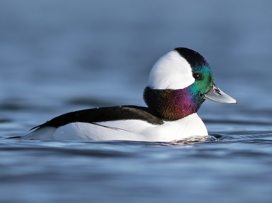
This page shows which locations in the selected region historically had the highest probability of a checklist including Bufflehead in February. Because some locations may be undersampled, the results are sorted based on a confidence score which takes into account how many samples are available. The bar chart shows how the probability of observing this species varies over the year.

Back to the Top Birds list

Rank Map Pics Location Distance Observed Sampled Frequency Confidence
1 William B. Umstead SP--Big Lake 5.7 117 129 90.7% 84.4%
2 Symphony Lake Greenway 4.4 130 155 83.9% 77.3%
3 Jordan Lake SRA--Parker's Creek 15.0 24 27 88.9% 71.9%
4 stakeout Long-tailed Duck, Lower Springdale Estates Lake, Raleigh (2019) 8.2 17 19 89.5% 68.6%
5 Lake Raleigh 6.0 150 214 70.1% 63.6%
6 Lake Lynn 7.7 133 189 70.4% 63.5%
7 Crabtree Creek Watershed 4.7 47 73 64.4% 52.9%
8 Lake Benson 11.9 98 166 59.0% 51.4%
9 Hoffman Lake 2.4 6 7 85.7% 48.7%
10 Apex Community Park 3.7 121 219 55.3% 48.6%
11 Lake Johnson Park 4.2 135 287 47.0% 41.3%
12 Lake Betz 7.3 162 364 44.5% 39.5%
13 Brier Creek Reservoir 5.9 83 191 43.5% 36.6%
14 Yates Mill County Park 7.2 224 574 39.0% 35.1%
15 Camden Ave Pond 16.3 2 2 100.0% 34.2%
16 South Point Mall Retention Pond 12.0 2 2 100.0% 34.2%
17 Salem Pond Park 4.5 10 19 52.6% 31.7%
18 Poplar Point Wastewater Ponds (Restricted Access) 13.8 3 4 75.0% 30.1%
19 West Lake Road Ponds 8.7 3 5 60.0% 23.1%
20 Jordan Lake SRA--New Hope Overlook 16.7 12 32 37.5% 22.9%
21 Carpenter Park 5.1 11 29 37.9% 22.7%
22 Briar Chapel--Pokeberry Creek 18.2 33 112 29.5% 21.8%
23 Inwood Rd. 7.3 18 55 32.7% 21.8%
24 North Carolina Museum of Art--Sculpture Garden 4.6 16 49 32.7% 21.2%
25 Butner Game Land--H Street Fields 23.2 2 3 66.7% 20.8%
26 Hilltop Needmore Park--South 11.5 2 3 66.7% 20.8%
27 Lick Creek Waterfowl Impoundment 13.2 1 1 100.0% 20.7%
28 Falls Lake--Mountains-to-Sea Trail South of Cheek Rd. 17.4 1 1 100.0% 20.7%
29 Jordan Lake--Historical Data Only 15.3 8 22 36.4% 19.7%
30 Old Oxford Rd. Pond 20.9 3 6 50.0% 18.8%
31 William B. Umstead SP--Reedy Creek Lake 3.8 6 16 37.5% 18.5%
32 Schenck Forest 3.6 80 372 21.5% 17.6%
33 Lake Rogers Park 23.7 4 10 40.0% 16.8%
34 Macedonia Lake/Speight Branch Greenway 3.5 9 32 28.1% 15.6%
35 William B. Umstead SP 5.4 7 25 28.0% 14.3%
36 Mid Pines Rd. 6.7 103 717 14.4% 12.0%
37 Eden Lakes 23.7 2 5 40.0% 11.8%
38 Howling Cow Creamery 7.2 4 14 28.6% 11.7%
39 Jordan Lake SRA--Ebenezer Point 15.0 36 235 15.3% 11.3%
40 NCSU Experimental Farm 7.1 8 38 21.1% 11.1%
41 Lake Crabtree County Park 3.6 79 583 13.6% 11.0%
42 Bond Park 2.7 28 187 15.0% 10.6%
43 Jordan Lake--NC Forest HQ (Model Plane Field) 14.1 4 16 25.0% 10.2%
44 Bass Lake Park & Trail 10.7 16 104 15.4% 9.7%
45 Discovery Lake (Restricted Access) 8.2 11 71 15.5% 8.9%
46 Lake Crabtree Nature Trail--Southport Entrance 3.3 20 155 12.9% 8.5%
47 Flat River Waterfowl Impoundment 23.4 22 180 12.2% 8.2%
48 Falls Lake--Rolling View 16.1 9 65 13.8% 7.5%
49 Falls Lake--Beaverdam Reservoir 18.0 4 23 17.4% 7.0%
50 North Carolina Museum of Art--Pond 4.7 4 23 17.4% 7.0%
51 Harris Lake County Park 14.0 12 118 10.2% 5.9%
52 Ten-Ten Road Pond 9.4 3 18 16.7% 5.8%
53 Falls Lake--Hwy. 50 Boat Ramp 16.8 2 11 18.2% 5.1%
54 Jordan Lake SRA--Seaforth 14.9 11 125 8.8% 5.0%
55 Jordan Lake--Educational State Forest 14.7 5 44 11.4% 5.0%
56 Maple View Farm (Birding From Roads Only) 24.1 12 146 8.2% 4.8%
57 Jordan Lake SRA--Vista Point 16.1 1 4 25.0% 4.6%
58 Horseshoe Road Nature Preserve 22.1 1 4 25.0% 4.6%
59 Hilltop Needmore Park--North 11.1 3 23 13.0% 4.5%
60 Baileywick Road Park 10.2 2 13 15.4% 4.3%
61 American Tobacco Trail--Southpoint Mall 12.2 2 13 15.4% 4.3%
62 Harris Game Land--Upper Boat Ramp 15.5 8 110 7.3% 3.7%
63 Laurel Hill Park 5.4 2 17 11.8% 3.3%
64 Falls Lake--Sandling Beach 17.5 1 6 16.7% 3.0%
65 Cape Fear River--Buckhorn Road 20.9 1 6 16.7% 3.0%
66 Indian Creek Greenway 3.5 2 19 10.5% 2.9%
67 William B. Umstead SP--Turkey Creek Trail 4.2 1 7 14.3% 2.6%
68 Jordan Game Land--Mason Point Peninsula 12.1 2 23 8.7% 2.4%
69 Lake Crabtree Dam 3.3 9 207 4.3% 2.3%
70 Lake Wheeler 8.2 3 51 5.9% 2.0%
71 Shelley Lake 8.1 7 184 3.8% 1.9%
72 Kildaire Farms Lake 2.3 1 11 9.1% 1.6%
73 Jordan Lake--Farrington Point Rd Causeway 12.9 1 12 8.3% 1.5%
74 Jordan Lake--Marthas Chapel Pulloff 12.6 1 12 8.3% 1.5%
75 Walnut Creek Greenway between Lake Dam Rd & Gorman St 5.1 1 12 8.3% 1.5%
76 Prairie Ridge Ecostation for Wildlife Learning 3.9 12 500 2.4% 1.4%
77 Falls Lake--Holly Pt./Shinleaf 15.9 1 13 7.7% 1.4%
78 Jordan Lake--New Hope Creek arm (Chatham Co) 12.0 1 14 7.1% 1.3%
79 AIHF Trail 8300 Health Park 10.0 1 14 7.1% 1.3%
80 Walnut Creek Wetland Center 9.0 1 15 6.7% 1.2%
81 White Oak Creek Greenway--Wetland 6.1 1 15 6.7% 1.2%
82 Falls Lake--Hickory Hill Boat Ramp 18.4 1 16 6.2% 1.1%
83 Morris Branch Greenway 7.6 1 17 5.9% 1.0%
84 Merritt's Pasture 16.9 1 18 5.6% 1.0%
85 Durant Nature Preserve 13.3 3 104 2.9% 1.0%
86 White Deer Park 11.6 2 58 3.4% 1.0%
87 Jordan Game Land--Farrington Point Boating Access 13.1 1 20 5.0% 0.9%
88 Ritter Park 4.3 1 25 4.0% 0.7%
89 Dorothea Dix Park 6.9 1 29 3.4% 0.6%
90 Lake Wheeler marshes 6.9 2 101 2.0% 0.5%
91 Crabtree Creek Wetland--West of Raleigh Blvd. 9.8 2 102 2.0% 0.5%
92 Wilkerson Nature Preserve Park 13.6 1 34 2.9% 0.5%
93 Butner Game Land--Brickhouse Rd. (Durham Co.) 21.9 1 67 1.5% 0.3%
94 Jordan Game Land--Transis Camp Rd. 12.6 1 67 1.5% 0.3%
95 Blue Jay Point County Park 14.5 1 112 0.9% 0.2%
96 Beaver Marsh 16.7 1 355 0.3% 0.0%