Where to find Eastern Kingbird in July
within 25 miles of New York City, United States
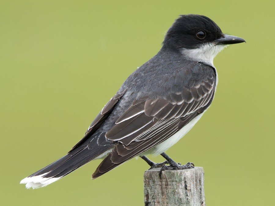
This page shows which locations in the selected region historically had the highest probability of a checklist including Eastern Kingbird in July. Because some locations may be undersampled, the results are sorted based on a confidence score which takes into account how many samples are available. The bar chart shows how the probability of observing this species varies over the year.
- Click on a month in the bar chart to switch to that month.
- Click on a location to view its top birds.
- Click here to view a map on eBird.
| Evidence | Sampling | Score | ||||||||
|---|---|---|---|---|---|---|---|---|---|---|
| # | Location | Dist | Media | Years | Birders | Hits | Lists | Freq | Conf | |
| 1 | Sharrotts Pond | 16.9 | 3 | 5 | 71 | 75 | 88 | 85.2% | 76.3% | |
| 2 | Lemon Creek Pier | 17.7 | 0 | 11 | 4 | 44 | 51 | 86.3% | 74.3% | |
| 3 | Ernest L. Oros Wildlife Preserve | 16.1 | 4 | 10 | 33 | 54 | 64 | 84.4% | 73.6% | |
| 4 | Lincoln Park Gravel Pits | 21.5 | 0 | 10 | 13 | 38 | 45 | 84.4% | 71.2% | |
| 5 | Green-Wood Cemetery, Brooklyn | 4.4 | 24 | 15 | 145 | 419 | 636 | 65.9% | 62.1% | |
| 6 | Cemetery of the Resurrection--North Overlook | 17.6 | 0 | 6 | 2 | 77 | 109 | 70.6% | 61.5% | |
| 7 | Cemetery of the Resurrection--Perpendicular Pond | 17.5 | 0 | 12 | 5 | 250 | 404 | 61.9% | 57.1% | |
| 8 | Baisley Pond Park | 11.8 | 0 | 6 | 7 | 9 | 11 | 81.8% | 52.3% | |
| 9 | Arthur J. Hendrickson Park | 16.4 | 0 | 3 | 2 | 10 | 13 | 76.9% | 49.7% | |
| 10 | River Rd. marshes and RR tracks | 11.9 | 0 | 11 | 17 | 38 | 62 | 61.3% | 48.8% | |
| 11 | Verona Park | 14.8 | 3 | 5 | 11 | 33 | 53 | 62.3% | 48.8% | |
| 12 | Flushing Meadows Corona Park--Meadow Lake | 8.8 | 8 | 8 | 19 | 47 | 80 | 58.8% | 47.8% | |
| 13 | Prospect Park | 4.2 | 23 | 23 | 222 | 641 | 1278 | 50.2% | 47.4% | |
| 14 | Central Park--Turtle Pond | 4.9 | 7 | 15 | 46 | 110 | 210 | 52.4% | 45.6% | |
| 15 | Dyker Beach Park | 7.1 | 2 | 7 | 3 | 24 | 40 | 60.0% | 44.6% | |
| 16 | John F. Kennedy Memorial Park | 23.7 | 1 | 2 | 3 | 3 | 3 | 100.0% | 43.8% | |
| 17 | Essex County Riverfront Park in Newark | 7.4 | 1 | 4 | 8 | 20 | 33 | 60.6% | 43.7% | |
| 18 | Cemetery of the Resurrection | 17.4 | 0 | 6 | 6 | 30 | 53 | 56.6% | 43.3% | |
| 19 | Melanie Lane Wetlands | 21.4 | 0 | 4 | 7 | 37 | 68 | 54.4% | 42.7% | |
| 20 | Loantaka Brook Reservation | 23.9 | 0 | 12 | 20 | 85 | 170 | 50.0% | 42.6% | |
| 21 | Cemetery of the Resurrection--scrub W of maint. bldgs | 17.6 | 0 | 6 | 1 | 55 | 110 | 50.0% | 40.8% | |
| 22 | Silver Lake Park (Richmond Co.) | 7.6 | 2 | 8 | 6 | 18 | 31 | 58.1% | 40.8% | |
| 23 | North Mt. Loretto SF--Snag Swamp | 17.8 | 0 | 4 | 1 | 26 | 48 | 54.2% | 40.3% | |
| 24 | Meadowlands IBA--Kearny Marsh | 7.4 | 6 | 16 | 22 | 39 | 76 | 51.3% | 40.3% | |
| 25 | Halsey Pond Park | 23.1 | 2 | 4 | 3 | 7 | 10 | 70.0% | 39.7% | |
| 26 | 5th Avenue Wetlands, Hackensack River | 24.6 | 0 | 3 | 8 | 19 | 34 | 55.9% | 39.5% | |
| 27 | Clove Lakes Park | 8.6 | 0 | 18 | 13 | 126 | 280 | 45.0% | 39.3% | |
| 28 | Mt. Loretto Unique Area | 18.0 | 2 | 18 | 55 | 59 | 125 | 47.2% | 38.7% | |
| 29 | Cemetery of the Resurrection--Parallel Pond | 17.4 | 0 | 13 | 1 | 83 | 188 | 44.1% | 37.2% | |
| 30 | Great Swamp NWR | 23.9 | 0 | 20 | 44 | 83 | 189 | 43.9% | 37.0% | |
| 31 | Clarks Pond | 11.9 | 0 | 4 | 4 | 13 | 23 | 56.5% | 36.8% | |
| 32 | Parsons Pond Park | 23.2 | 0 | 3 | 7 | 12 | 21 | 57.1% | 36.5% | |
| 33 | Cemetery of the Resurrection--S entrance (maint. bldgs) | 17.5 | 0 | 4 | 1 | 49 | 108 | 45.4% | 36.3% | |
| 34 | Nassau County Stormwater Basin No. 21 | 16.7 | 0 | 6 | 3 | 31 | 65 | 47.7% | 36.0% | |
| 35 | Spring Lake Park | 23.2 | 0 | 2 | 4 | 5 | 7 | 71.4% | 35.9% | |
| 36 | Highland Park (Queens Co.) | 6.6 | 0 | 3 | 2 | 5 | 7 | 71.4% | 35.9% | |
| 37 | White's Pond | 21.8 | 0 | 2 | 4 | 5 | 7 | 71.4% | 35.9% | |
| 38 | Weequahic Park | 10.3 | 2 | 5 | 3 | 9 | 15 | 60.0% | 35.7% | |
| 39 | Walker Avenue Wetlands | 20.7 | 1 | 15 | 25 | 85 | 206 | 41.3% | 34.8% | |
| 40 | Seguine Pond and waterfront | 15.7 | 0 | 1 | 2 | 2 | 2 | 100.0% | 34.2% | |
| 41 | Green Brook Park | 24.2 | 0 | 2 | 2 | 2 | 2 | 100.0% | 34.2% | |
| 42 | Randalls Island | 6.8 | 5 | 9 | 29 | 65 | 158 | 41.1% | 33.8% | |
| 43 | Van Cortlandt Park | 14.2 | 4 | 13 | 22 | 22 | 47 | 46.8% | 33.3% | |
| 44 | Alley Pond Park--Oakland Lake | 13.3 | 3 | 9 | 17 | 63 | 155 | 40.6% | 33.2% | |
| 45 | Garret Mountain Reservation (Park) | 15.7 | 2 | 14 | 20 | 70 | 175 | 40.0% | 33.0% | |
| 46 | Jacksons Pond | 15.7 | 1 | 7 | 5 | 8 | 14 | 57.1% | 32.6% | |
| 47 | Commerce Road Wetlands | 19.8 | 1 | 6 | 18 | 59 | 148 | 39.9% | 32.3% | |
| 48 | Cameron Field Park Pond | 13.6 | 0 | 4 | 5 | 10 | 19 | 52.6% | 31.7% | |
| 49 | Liberty SP | 2.4 | 7 | 16 | 31 | 131 | 360 | 36.4% | 31.6% | |
| 50 | Lincoln Park West | 4.5 | 1 | 6 | 13 | 14 | 29 | 48.3% | 31.4% | |
| 51 | The Celery Farm | 23.1 | 6 | 20 | 61 | 189 | 536 | 35.3% | 31.3% | |
| 52 | Whitney Pond Park | 16.6 | 0 | 6 | 1 | 9 | 17 | 52.9% | 31.0% | |
| 53 | Mindowaskin Park | 18.3 | 0 | 2 | 1 | 9 | 17 | 52.9% | 31.0% | |
| 54 | Sunset Park (Brooklyn) | 4.6 | 4 | 5 | 4 | 42 | 108 | 38.9% | 30.2% | |
| 55 | Freshkills Park--North Mound | 13.1 | 0 | 1 | 5 | 3 | 4 | 75.0% | 30.1% | |
| 56 | Best Lake | 23.8 | 0 | 2 | 3 | 3 | 4 | 75.0% | 30.1% | |
| 57 | Arbutus Lake | 16.0 | 0 | 5 | 2 | 13 | 28 | 46.4% | 29.5% | |
| 58 | Orange Reservoir | 15.0 | 5 | 6 | 16 | 20 | 47 | 42.6% | 29.5% | |
| 59 | Crocheron Park | 13.1 | 1 | 5 | 9 | 9 | 18 | 50.0% | 29.0% | |
| 60 | West Essex Wetlands, Livingston, New Jersey, US (40.808, -74.344) | 18.9 | 0 | 3 | 9 | 20 | 48 | 41.7% | 28.8% | |
| 61 | Coney Island Creek Park | 9.2 | 1 | 9 | 12 | 16 | 37 | 43.2% | 28.7% | |
| 62 | Prospect Park--Prospect Lake | 4.5 | 0 | 10 | 31 | 39 | 105 | 37.1% | 28.5% | |
| 63 | Oak Ridge Park | 19.5 | 0 | 4 | 3 | 8 | 16 | 50.0% | 28.0% | |
| 64 | Green-Wood Cemetery--Sylvan Water | 4.2 | 1 | 4 | 12 | 12 | 27 | 44.4% | 27.6% | |
| 65 | Van Cortlandt Park--VC Lake and Vault Hill | 13.9 | 0 | 6 | 6 | 7 | 14 | 50.0% | 26.8% | |
| 66 | Rahway River--Yacht Club Overlook | 15.5 | 0 | 3 | 2 | 7 | 14 | 50.0% | 26.8% | |
| 67 | Florham Park--Fish Tract | 19.8 | 0 | 2 | 2 | 5 | 9 | 55.6% | 26.7% | |
| 68 | Pelham Bay Park--Thomas Pell WS and Goose Creek Marsh | 15.0 | 0 | 6 | 6 | 14 | 34 | 41.2% | 26.4% | |
| 69 | Goodhue Park | 7.2 | 0 | 5 | 1 | 30 | 84 | 35.7% | 26.3% | |
| 70 | Green-Wood Cemetery--Dell Water | 4.5 | 1 | 4 | 7 | 8 | 17 | 47.1% | 26.2% | |
| 71 | Freshkills Park | 13.4 | 1 | 6 | 13 | 15 | 38 | 39.5% | 25.6% | |
| 72 | Freshkills Park--North Park (Phase l) | 12.8 | 1 | 2 | 8 | 6 | 12 | 50.0% | 25.4% | |
| 73 | Milton Lake Park | 17.0 | 0 | 3 | 3 | 4 | 7 | 57.1% | 25.0% | |
| 74 | Alley Pond Park--Restoration Area | 14.0 | 1 | 2 | 3 | 4 | 7 | 57.1% | 25.0% | |
| 75 | Lake Matawan | 23.8 | 0 | 1 | 3 | 4 | 7 | 57.1% | 25.0% | |
| 76 | Roslyn Pond Town Park | 19.6 | 0 | 6 | 5 | 7 | 15 | 46.7% | 24.8% | |
| 77 | Bronx Zoo | 11.6 | 0 | 13 | 9 | 70 | 232 | 30.2% | 24.6% | |
| 78 | Woodlawn Cemetery | 14.0 | 0 | 2 | 4 | 8 | 18 | 44.4% | 24.6% | |
| 79 | Central Park | 4.3 | 18 | 23 | 86 | 242 | 884 | 27.4% | 24.5% | |
| 80 | Franklin Lakes Nature Preserve | 21.1 | 0 | 6 | 8 | 10 | 24 | 41.7% | 24.5% | |
| 81 | Disposal Rd. | 7.7 | 0 | 10 | 14 | 29 | 87 | 33.3% | 24.3% | |
| 82 | Linden Hawk Rise Sanctuary | 14.8 | 1 | 16 | 25 | 67 | 227 | 29.5% | 24.0% | |
| 83 | Ridgewood Reservoir | 6.5 | 2 | 6 | 8 | 11 | 28 | 39.3% | 23.6% | |
| 84 | Hempstead Lake SP--south end | 18.9 | 0 | 13 | 11 | 41 | 135 | 30.4% | 23.2% | |
| 85 | Overpeck County Park--Henry Hoebel Area | 10.7 | 0 | 4 | 6 | 6 | 13 | 46.2% | 23.2% | |
| 86 | Udall's Mill Pond | 14.7 | 3 | 4 | 10 | 13 | 35 | 37.1% | 23.2% | |
| 87 | Ash Brook Reservation | 19.7 | 0 | 3 | 3 | 3 | 5 | 60.0% | 23.1% | |
| 88 | Central Park-Hanover Twp./Whippany Paper Board (private) | 23.6 | 0 | 2 | 1 | 3 | 5 | 60.0% | 23.1% | |
| 89 | Crotona Park | 10.4 | 0 | 2 | 3 | 3 | 5 | 60.0% | 23.1% | |
| 90 | Lyndhurst Mansion (grounds), Tarrytown | 24.6 | 0 | 2 | 2 | 3 | 5 | 60.0% | 23.1% | |
| 91 | Richard A. Rutkowski Park | 5.8 | 3 | 10 | 15 | 31 | 102 | 30.4% | 22.3% | |
| 92 | Clay Pit Ponds | 17.0 | 0 | 2 | 4 | 4 | 8 | 50.0% | 21.5% | |
| 93 | Goffle Brook Park | 17.9 | 0 | 1 | 4 | 4 | 8 | 50.0% | 21.5% | |
| 94 | Van Cortlandt Park--Southwest Zone | 13.8 | 1 | 5 | 6 | 6 | 14 | 42.9% | 21.4% | |
| 95 | South Amboy Waterworks Pond (Judge Hoffman Wildlife Refuge) | 21.8 | 0 | 5 | 5 | 5 | 11 | 45.5% | 21.3% | |
| 96 | Brooklyn Botanic Garden | 3.9 | 3 | 11 | 31 | 56 | 210 | 26.7% | 21.1% | |
| 97 | East Irvington Nature Preserve | 24.6 | 0 | 1 | 2 | 2 | 3 | 66.7% | 20.8% | |
| 98 | Bowne Park, Flushing | 11.1 | 0 | 1 | 2 | 2 | 3 | 66.7% | 20.8% | |
| 99 | McFaul Environmental Center | 21.7 | 0 | 3 | 5 | 10 | 28 | 35.7% | 20.7% | |
| 100 | Crestwood Lake, Yonkers | 20.1 | 0 | 1 | 1 | 1 | 1 | 100.0% | 20.7% | |
| 101 | Van Name-Van Pelt Cove | 9.4 | 0 | 1 | 1 | 1 | 1 | 100.0% | 20.7% | |
| 102 | Silver Lake Reservoir | 7.5 | 0 | 1 | 1 | 1 | 1 | 100.0% | 20.7% | |
| 103 | Darwin James Preserve (private) | 21.6 | 0 | 1 | 2 | 1 | 1 | 100.0% | 20.7% | |
| 104 | Wyckoff Lake | 24.1 | 1 | 1 | 1 | 1 | 1 | 100.0% | 20.7% | |
| 105 | Randalls Island--Southeast section | 6.2 | 0 | 1 | 1 | 1 | 1 | 100.0% | 20.7% | |
| 106 | Eibs Pond Park | 8.1 | 0 | 1 | 2 | 1 | 1 | 100.0% | 20.7% | |
| 107 | Riverside County Park (Lyndhurst) | 9.8 | 0 | 1 | 2 | 1 | 1 | 100.0% | 20.7% | |
| 108 | St. Michael’s Cemetery, East Elmhurst | 6.6 | 1 | 1 | 1 | 1 | 1 | 100.0% | 20.7% | |
| 109 | Roberto Clemente State Park | 10.8 | 0 | 1 | 1 | 1 | 1 | 100.0% | 20.7% | |
| 110 | Snug Harbor Cultural Center--Heritage Farm | 7.1 | 0 | 1 | 1 | 1 | 1 | 100.0% | 20.7% | |
| 111 | Calvert Vaux Park (Dreier-Offerman Park) | 9.0 | 1 | 15 | 18 | 55 | 212 | 25.9% | 20.5% | |
| 112 | Flushing Airport | 10.0 | 0 | 1 | 2 | 7 | 18 | 38.9% | 20.3% | |
| 113 | South Mountain Reservation | 15.5 | 3 | 7 | 12 | 23 | 80 | 28.7% | 20.0% | |
| 114 | Sands Point Preserve | 19.0 | 0 | 9 | 19 | 22 | 77 | 28.6% | 19.7% | |
| 115 | Troy Meadows Natural Area | 21.1 | 1 | 10 | 17 | 26 | 94 | 27.7% | 19.6% | |
| 116 | Inwood Hill Park | 11.7 | 0 | 12 | 34 | 156 | 700 | 22.3% | 19.4% | |
| 117 | Dismal Swamp | 22.9 | 0 | 2 | 2 | 5 | 12 | 41.7% | 19.3% | |
| 118 | Pelham Bay Park | 14.8 | 0 | 11 | 13 | 30 | 113 | 26.5% | 19.3% | |
| 119 | Blauvelt Road Bridge (Hackensack River/Lake Tappan) | 24.0 | 0 | 3 | 5 | 7 | 19 | 36.8% | 19.1% | |
| 120 | New York Botanical Garden | 12.3 | 2 | 13 | 40 | 41 | 164 | 25.0% | 19.0% | |
| 121 | Bee Meadow Park | 22.8 | 0 | 2 | 3 | 4 | 9 | 44.4% | 18.9% | |
| 122 | Pond Park, Great Neck Estates | 14.6 | 0 | 1 | 2 | 4 | 9 | 44.4% | 18.9% | |
| 123 | Raritan Center (Restricted Access) | 23.0 | 0 | 3 | 3 | 3 | 6 | 50.0% | 18.8% | |
| 124 | Grover Cleveland Park and Essex Fells | 16.8 | 0 | 2 | 3 | 3 | 6 | 50.0% | 18.8% | |
| 125 | Great Neck Estates Park | 14.3 | 0 | 3 | 1 | 3 | 6 | 50.0% | 18.8% | |
| 126 | VE Macy Park--Great Hunger Memorial | 23.0 | 1 | 1 | 1 | 3 | 6 | 50.0% | 18.8% | |
| 127 | Richard W. DeKorte Park | 6.9 | 16 | 18 | 138 | 325 | 1597 | 20.4% | 18.4% | |
| 128 | Bridge Creek, Western Ave. | 10.9 | 0 | 9 | 6 | 16 | 56 | 28.6% | 18.4% | |
| 129 | Pelham Bay Park--The Meadow and adj. woodland | 15.0 | 0 | 3 | 3 | 5 | 13 | 38.5% | 17.7% | |
| 130 | Tanglewood Preserve | 18.5 | 0 | 4 | 2 | 7 | 21 | 33.3% | 17.2% | |
| 131 | Smith Pond, Rockville Center | 18.8 | 0 | 3 | 4 | 4 | 10 | 40.0% | 16.8% | |
| 132 | Brookville Park | 14.2 | 6 | 4 | 3 | 8 | 26 | 30.8% | 16.5% | |
| 133 | Tibbetts Brook Park | 15.9 | 1 | 2 | 3 | 5 | 14 | 35.7% | 16.3% | |
| 134 | Lake Tappan (NY) | 23.3 | 1 | 2 | 12 | 11 | 40 | 27.5% | 16.1% | |
| 135 | Governors Island (reopening Spring 2021) | 1.9 | 14 | 10 | 39 | 89 | 462 | 19.3% | 15.9% | |
| 136 | Pelham Bay Park--Turtle Cove | 14.7 | 3 | 10 | 7 | 24 | 105 | 22.9% | 15.9% | |
| 137 | Fort Washington Park--S of GWB (Little Red Lighthouse-155th St.) | 9.4 | 3 | 2 | 3 | 8 | 27 | 29.6% | 15.9% | |
| 138 | Mariners Marsh | 10.3 | 0 | 2 | 1 | 3 | 7 | 42.9% | 15.8% | |
| 139 | Overpeck County Park | 10.5 | 1 | 11 | 10 | 24 | 106 | 22.6% | 15.7% | |
| 140 | Flushing Meadows Corona Park | 8.8 | 0 | 5 | 6 | 10 | 37 | 27.0% | 15.4% | |
| 141 | Kissena Park | 10.6 | 1 | 8 | 11 | 11 | 42 | 26.2% | 15.3% | |
| 142 | North Mt. Loretto SF | 17.9 | 0 | 2 | 2 | 5 | 15 | 33.3% | 15.2% | |
| 143 | Brightwood Park | 19.5 | 0 | 4 | 3 | 5 | 15 | 33.3% | 15.2% | |
| 144 | West Essex Wetlands | 18.9 | 0 | 3 | 2 | 5 | 15 | 33.3% | 15.2% | |
| 145 | Moravian Cemetery | 10.9 | 0 | 4 | 6 | 4 | 11 | 36.4% | 15.2% | |
| 146 | Cedarmere Preserve | 20.0 | 0 | 2 | 2 | 2 | 4 | 50.0% | 15.0% | |
| 147 | Merillon Park, Lake Success | 16.7 | 1 | 1 | 1 | 2 | 4 | 50.0% | 15.0% | |
| 148 | Jersey Gardens Mall--Bayfront Wetlands--Restricted Access | 9.1 | 2 | 3 | 5 | 11 | 43 | 25.6% | 14.9% | |
| 149 | Saw Mill Creek Trail | 7.3 | 0 | 5 | 9 | 11 | 44 | 25.0% | 14.6% | |
| 150 | Lemon Creek Park | 17.2 | 0 | 6 | 2 | 16 | 71 | 22.5% | 14.4% | |
| 151 | Central Park--Greywacke Arch | 5.0 | 0 | 7 | 1 | 15 | 67 | 22.4% | 14.1% | |
| 152 | Central Park--North End | 6.2 | 2 | 9 | 19 | 24 | 119 | 20.2% | 13.9% | |
| 153 | Woodlands Lake | 23.2 | 1 | 3 | 3 | 3 | 8 | 37.5% | 13.7% | |
| 154 | Sandy Hook | 19.0 | 2 | 16 | 45 | 75 | 446 | 16.8% | 13.6% | |
| 155 | Maplewood Memorial Park | 14.1 | 1 | 5 | 3 | 21 | 106 | 19.8% | 13.3% | |
| 156 | Swindler Cove Park and Sherman Creek | 10.9 | 6 | 10 | 15 | 33 | 183 | 18.0% | 13.1% | |
| 157 | Stephen R. Gregg County Park | 6.1 | 1 | 5 | 5 | 5 | 18 | 27.8% | 12.5% | |
| 158 | Freshkills Park--East Mound | 12.6 | 0 | 3 | 4 | 5 | 18 | 27.8% | 12.5% | |
| 159 | Manhasset Valley County Park | 16.5 | 0 | 5 | 2 | 5 | 18 | 27.8% | 12.5% | |
| 160 | Watchung Reservation | 19.7 | 0 | 6 | 4 | 10 | 46 | 21.7% | 12.3% | |
| 161 | Fort Totten Park | 13.2 | 1 | 4 | 5 | 7 | 29 | 24.1% | 12.2% | |
| 162 | Wolfe's Pond Park | 16.8 | 0 | 11 | 9 | 31 | 184 | 16.8% | 12.1% | |
| 163 | Central Park--Tupelo Meadow | 4.8 | 0 | 3 | 3 | 3 | 9 | 33.3% | 12.1% | |
| 164 | Crestwood Park | 23.3 | 0 | 2 | 3 | 3 | 9 | 33.3% | 12.1% | |
| 165 | Miller Field | 11.3 | 0 | 7 | 6 | 26 | 152 | 17.1% | 11.9% | |
| 166 | Cedar Brook Park | 22.4 | 0 | 1 | 2 | 2 | 5 | 40.0% | 11.8% | |
| 167 | Troy Meadows Natural Area--So. Beverwyck Rd/Patriots Path | 21.6 | 0 | 4 | 3 | 4 | 14 | 28.6% | 11.7% | |
| 168 | Duck Pond (Gardens Lake), Larchmont | 20.7 | 0 | 2 | 1 | 4 | 14 | 28.6% | 11.7% | |
| 169 | Echo Lake Park | 18.0 | 0 | 7 | 8 | 11 | 55 | 20.0% | 11.6% | |
| 170 | Teaneck Creek Conservancy | 11.1 | 0 | 3 | 8 | 16 | 91 | 17.6% | 11.1% | |
| 171 | Oradell Reservoir and Emerson Woods | 17.7 | 0 | 6 | 5 | 8 | 38 | 21.1% | 11.1% | |
| 172 | Snug Harbor Cultural Center & Botanical Garden | 7.1 | 0 | 7 | 5 | 9 | 45 | 20.0% | 10.9% | |
| 173 | Fresh Creek Park | 8.1 | 0 | 2 | 4 | 3 | 10 | 30.0% | 10.8% | |
| 174 | Florham Park Fields | 21.4 | 0 | 3 | 3 | 3 | 10 | 30.0% | 10.8% | |
| 175 | Hempstead Lake SP | 19.2 | 1 | 9 | 12 | 13 | 73 | 17.8% | 10.7% | |
| 176 | Closter Nature Center | 18.3 | 0 | 3 | 5 | 14 | 81 | 17.3% | 10.6% | |
| 177 | North Mt. Loretto SF--Reed Marsh | 17.6 | 0 | 2 | 1 | 10 | 54 | 18.5% | 10.4% | |
| 178 | Van Saun Park--Walden Pond | 14.7 | 0 | 5 | 2 | 7 | 34 | 20.6% | 10.3% | |
| 179 | Rahway River Park | 16.1 | 0 | 4 | 2 | 4 | 16 | 25.0% | 10.2% | |
| 180 | Sound View Park | 9.9 | 0 | 1 | 1 | 4 | 16 | 25.0% | 10.2% | |
| 181 | Mission of Immaculate Virgin, Mt. Loretto | 17.9 | 1 | 5 | 3 | 6 | 29 | 20.7% | 9.8% | |
| 182 | Van Saun Park | 15.0 | 1 | 3 | 3 | 3 | 11 | 27.3% | 9.7% | |
| 183 | Clay Ave. Wetland (Tessie McNamara Park) | 7.9 | 0 | 6 | 13 | 20 | 136 | 14.7% | 9.7% | |
| 184 | Bloodgoods Pond | 16.4 | 1 | 2 | 4 | 2 | 6 | 33.3% | 9.7% | |
| 185 | Lister Park | 18.9 | 0 | 2 | 3 | 2 | 6 | 33.3% | 9.7% | |
| 186 | Randalls Island--Icahn Stadium and environs | 6.9 | 0 | 1 | 2 | 2 | 6 | 33.3% | 9.7% | |
| 187 | Miller Field--Beach | 11.3 | 0 | 4 | 2 | 5 | 23 | 21.7% | 9.7% | |
| 188 | Rockland Psychiatric Pond & environs | 23.2 | 2 | 2 | 7 | 11 | 66 | 16.7% | 9.6% | |
| 189 | Flushing Meadows Corona Park--Willow Lake | 9.1 | 0 | 5 | 3 | 6 | 30 | 20.0% | 9.5% | |
| 190 | Flushing Meadows Corona Park--Porpoise Bridge | 9.1 | 0 | 3 | 3 | 7 | 37 | 18.9% | 9.5% | |
| 191 | Lenape Park | 16.4 | 0 | 8 | 9 | 10 | 59 | 16.9% | 9.5% | |
| 192 | North Shore Esplanade | 6.0 | 0 | 1 | 1 | 1 | 2 | 50.0% | 9.5% | |
| 193 | Clove Lakes Park--Southern Woodlands | 8.7 | 0 | 1 | 1 | 1 | 2 | 50.0% | 9.5% | |
| 194 | Freshkills Park--South Mounds | 13.6 | 0 | 1 | 1 | 1 | 2 | 50.0% | 9.5% | |
| 195 | Veterans Park (Hazlet) | 21.9 | 0 | 1 | 1 | 1 | 2 | 50.0% | 9.5% | |
| 196 | Monk Parakeet Nest--Carteret | 15.1 | 0 | 1 | 1 | 1 | 2 | 50.0% | 9.5% | |
| 197 | Troy Meadows--Alan Dr. access, gas-line trails and deer exclosure | 21.9 | 0 | 1 | 1 | 1 | 2 | 50.0% | 9.5% | |
| 198 | Todt Hill Woodlands | 10.1 | 0 | 1 | 1 | 1 | 2 | 50.0% | 9.5% | |
| 199 | Short Hills Ponds | 16.7 | 0 | 1 | 1 | 1 | 2 | 50.0% | 9.5% | |
| 200 | River Park (Bronx Co.) | 11.2 | 0 | 1 | 1 | 1 | 2 | 50.0% | 9.5% | |
| 201 | Flushing Creek | 9.4 | 0 | 1 | 1 | 1 | 2 | 50.0% | 9.5% | |
| 202 | Meadowlands IBA--Mill Creek Marsh | 6.1 | 2 | 13 | 29 | 43 | 347 | 12.4% | 9.3% | |
| 203 | Pelham Bay Park--Southern Meadow and environs | 13.6 | 1 | 6 | 8 | 7 | 38 | 18.4% | 9.2% | |
| 204 | Hempstead Lake SP--north end | 19.3 | 0 | 4 | 7 | 7 | 38 | 18.4% | 9.2% | |
| 205 | Central Park--Harlem Meer | 6.4 | 4 | 6 | 6 | 8 | 46 | 17.4% | 9.1% | |
| 206 | Central Park--The Ramble | 4.7 | 1 | 14 | 39 | 59 | 518 | 11.4% | 8.9% | |
| 207 | Meadowlands IBA--Losen Slote Creek Park | 8.8 | 0 | 1 | 4 | 3 | 12 | 25.0% | 8.9% | |
| 208 | Marshlands Conservancy | 22.9 | 5 | 15 | 49 | 59 | 528 | 11.2% | 8.8% | |
| 209 | Lake Tappan (NY), Convent Rd. | 23.5 | 0 | 3 | 21 | 18 | 135 | 13.3% | 8.6% | |
| 210 | Hatfield Swamp IBA--West Essex Park | 18.2 | 1 | 7 | 5 | 15 | 108 | 13.9% | 8.6% | |
| 211 | Oceanside Marine Nature Study Area | 21.0 | 3 | 21 | 41 | 129 | 1322 | 9.8% | 8.3% | |
| 212 | Warinanco Park | 12.8 | 0 | 2 | 2 | 2 | 7 | 28.6% | 8.2% | |
| 213 | Prospect Park--Feeders | 4.4 | 0 | 1 | 1 | 2 | 7 | 28.6% | 8.2% | |
| 214 | Irvington Woods | 23.8 | 0 | 2 | 2 | 2 | 7 | 28.6% | 8.2% | |
| 215 | Cameron Lake | 8.8 | 0 | 2 | 1 | 2 | 7 | 28.6% | 8.2% | |
| 216 | Edgemont Memorial Park | 13.5 | 0 | 2 | 2 | 2 | 7 | 28.6% | 8.2% | |
| 217 | Dundee Island Preserve | 13.2 | 1 | 2 | 2 | 2 | 7 | 28.6% | 8.2% | |
| 218 | Harvey Park | 10.7 | 0 | 1 | 1 | 2 | 7 | 28.6% | 8.2% | |
| 219 | Randalls Island--NW fields and shoreline | 7.4 | 1 | 4 | 5 | 5 | 27 | 18.5% | 8.2% | |
| 220 | Cunningham Park | 12.6 | 0 | 3 | 2 | 3 | 13 | 23.1% | 8.2% | |
| 221 | Silver Lake (Bergen Co.) | 22.4 | 0 | 3 | 2 | 3 | 13 | 23.1% | 8.2% | |
| 222 | Alley Pond Park--Environmental Center | 13.6 | 0 | 8 | 9 | 12 | 86 | 14.0% | 8.2% | |
| 223 | Cemetery of the Resurrection--N entrance | 17.3 | 0 | 5 | 1 | 29 | 254 | 11.4% | 8.1% | |
| 224 | Saw Mill Creek Marsh | 12.1 | 0 | 4 | 6 | 5 | 28 | 17.9% | 7.9% | |
| 225 | Pelham Bay Park--Bartow-Pell Mansion | 15.1 | 0 | 1 | 4 | 3 | 14 | 21.4% | 7.6% | |
| 226 | Oakwood Beach--tidal marshes, NW to Mill Rd. | 12.7 | 0 | 5 | 1 | 15 | 129 | 11.6% | 7.2% | |
| 227 | Naaktpunkt Stream, Swamp & Woods | 18.1 | 0 | 1 | 1 | 2 | 8 | 25.0% | 7.1% | |
| 228 | Glen Island Park | 16.6 | 1 | 2 | 2 | 2 | 8 | 25.0% | 7.1% | |
| 229 | Poplar Rd. Wildlife Sanctuary | 21.2 | 0 | 2 | 2 | 2 | 8 | 25.0% | 7.1% | |
| 230 | Staten Island Industrial Park--Pond (South Ave. X Glen St.) | 10.7 | 0 | 1 | 1 | 2 | 8 | 25.0% | 7.1% | |
| 231 | Willow Pond, Hewlett Bay Park | 17.3 | 1 | 2 | 2 | 2 | 8 | 25.0% | 7.1% | |
| 232 | Hilltop Reservation--Courter Lane | 15.9 | 1 | 2 | 2 | 2 | 8 | 25.0% | 7.1% | |
| 233 | Owls Head Park | 5.3 | 0 | 2 | 1 | 3 | 15 | 20.0% | 7.0% | |
| 234 | Mill Creek | 18.2 | 0 | 2 | 1 | 4 | 23 | 17.4% | 7.0% | |
| 235 | Raritan Bay Waterfront Park & Morgan Avenue Mudflats | 21.4 | 0 | 9 | 16 | 26 | 265 | 9.8% | 6.8% | |
| 236 | North Mt. Loretto SF--Sand Pits (Turtle Nesting Area) | 17.6 | 0 | 1 | 1 | 4 | 24 | 16.7% | 6.7% | |
| 237 | Brookdale Park | 12.7 | 0 | 6 | 4 | 7 | 52 | 13.5% | 6.7% | |
| 238 | Central Park--Reservoir | 5.5 | 0 | 7 | 16 | 20 | 197 | 10.2% | 6.7% | |
| 239 | Old Place Creek--Kayak Access Site | 11.0 | 0 | 3 | 5 | 6 | 43 | 14.0% | 6.6% | |
| 240 | Sheldrake Lake (Larchmont Reservoir) | 20.5 | 0 | 4 | 4 | 5 | 34 | 14.7% | 6.4% | |
| 241 | Meadowlands IBA--Kearny Marsh East | 5.9 | 0 | 5 | 4 | 7 | 54 | 13.0% | 6.4% | |
| 242 | Coney Island Creek--Leon S. Kaiser Park | 9.2 | 0 | 2 | 2 | 2 | 9 | 22.2% | 6.3% | |
| 243 | "Sandy Hook--Hudson Rd (""The Garden"", etc)" | 17.2 | 0 | 1 | 2 | 2 | 9 | 22.2% | 6.3% | |
| 244 | Pelham Bay Park--Bridle Path around golf courses | 15.0 | 0 | 2 | 2 | 2 | 9 | 22.2% | 6.3% | |
| 245 | Randalls Island--Ferry Dock and environs | 7.1 | 1 | 2 | 2 | 2 | 9 | 22.2% | 6.3% | |
| 246 | Mill Pond, Port Washington | 18.2 | 0 | 3 | 2 | 3 | 17 | 17.6% | 6.2% | |
| 247 | Kingsland Park and Yantacaw Pond | 10.5 | 0 | 1 | 1 | 1 | 3 | 33.3% | 6.1% | |
| 248 | Clason Point | 10.0 | 0 | 1 | 1 | 1 | 3 | 33.3% | 6.1% | |
| 249 | Stepping Stone Park | 14.9 | 0 | 1 | 1 | 1 | 3 | 33.3% | 6.1% | |
| 250 | Branch Brook Park--North | 10.0 | 0 | 1 | 1 | 1 | 3 | 33.3% | 6.1% | |
| 251 | Spanish Camp, Former | 15.7 | 0 | 1 | 1 | 1 | 3 | 33.3% | 6.1% | |
| 252 | MacNeil Park | 9.7 | 0 | 1 | 1 | 1 | 3 | 33.3% | 6.1% | |
| 253 | Rufus King Park, Jamaica | 10.6 | 0 | 1 | 1 | 1 | 3 | 33.3% | 6.1% | |
| 254 | Watchung Reservation--Scout Camp area | 19.5 | 0 | 1 | 1 | 1 | 3 | 33.3% | 6.1% | |
| 255 | Union Field Cemetery | 6.4 | 0 | 1 | 2 | 1 | 3 | 33.3% | 6.1% | |
| 256 | Reynolds Field, Hastings-on-Hudson | 20.6 | 0 | 1 | 1 | 1 | 3 | 33.3% | 6.1% | |
| 257 | Jacob Javits Playground, Washington Heights | 10.7 | 0 | 1 | 1 | 1 | 3 | 33.3% | 6.1% | |
| 258 | Cable Way, Graniteville | 10.3 | 0 | 1 | 1 | 1 | 3 | 33.3% | 6.1% | |
| 259 | Hilltop Reservation--Read Ave./Cedar Grove Park | 15.7 | 0 | 1 | 1 | 1 | 3 | 33.3% | 6.1% | |
| 260 | Freshkills Park--East Mound--Western Retention Ponds (restricted access) | 13.3 | 0 | 1 | 1 | 1 | 3 | 33.3% | 6.1% | |
| 261 | Central Park--The Pool | 6.0 | 0 | 1 | 11 | 14 | 139 | 10.1% | 6.1% | |
| 262 | Prospect Park--Vale of Cashmere | 3.7 | 0 | 3 | 5 | 6 | 47 | 12.8% | 6.0% | |
| 263 | Cheesequake State Park | 23.6 | 2 | 7 | 8 | 9 | 81 | 11.1% | 6.0% | |
| 264 | Pelham Bay Park--Twin Islands | 15.9 | 0 | 3 | 2 | 3 | 18 | 16.7% | 5.8% | |
| 265 | Barbour Pond Park | 20.9 | 0 | 2 | 2 | 3 | 18 | 16.7% | 5.8% | |
| 266 | The Landing, Dobbs Ferry | 22.1 | 2 | 4 | 4 | 11 | 108 | 10.2% | 5.8% | |
| 267 | Hillview Reservoir (restricted access) | 15.4 | 0 | 6 | 3 | 10 | 97 | 10.3% | 5.7% | |
| 268 | Schlegel Lake | 19.0 | 0 | 2 | 2 | 2 | 10 | 20.0% | 5.7% | |
| 269 | North Cove, Inwood | 11.4 | 0 | 2 | 2 | 2 | 10 | 20.0% | 5.7% | |
| 270 | Central Park--The Lake | 4.7 | 0 | 6 | 5 | 6 | 50 | 12.0% | 5.6% | |
| 271 | Frank M. Chapman Birding Trail | 13.8 | 0 | 1 | 2 | 3 | 19 | 15.8% | 5.5% | |
| 272 | Goethals Bridge Pond--Goethals Homes | 10.8 | 0 | 2 | 5 | 5 | 40 | 12.5% | 5.5% | |
| 273 | Jefferson Rd. Pond | 23.4 | 0 | 4 | 7 | 7 | 64 | 10.9% | 5.4% | |
| 274 | Brookfield Park | 13.3 | 0 | 4 | 3 | 6 | 52 | 11.5% | 5.4% | |
| 275 | Salt Marsh Nature Center at Marine Park | 9.1 | 2 | 15 | 41 | 41 | 575 | 7.1% | 5.3% | |
| 276 | Saddle River County Park | 14.4 | 1 | 2 | 3 | 3 | 20 | 15.0% | 5.2% | |
| 277 | Meadowlands IBA--Harrier Meadows (restricted access) | 7.8 | 0 | 4 | 5 | 7 | 66 | 10.6% | 5.2% | |
| 278 | Marciante-Jackson-Millet Park | 9.9 | 0 | 2 | 2 | 9 | 93 | 9.7% | 5.2% | |
| 279 | Van Cortlandt Park--NW Forest | 14.5 | 0 | 1 | 1 | 2 | 11 | 18.2% | 5.1% | |
| 280 | Passaic River South Orange Ave Boat Launch Livingston | 19.5 | 0 | 2 | 1 | 2 | 11 | 18.2% | 5.1% | |
| 281 | Flushing Meadows Corona Park--Meridian Rd. Circle (Museum, Unisphere etc.) | 8.9 | 0 | 2 | 3 | 4 | 31 | 12.9% | 5.1% | |
| 282 | Meadowlands IBA--Mill Creek Point | 6.7 | 0 | 7 | 5 | 10 | 108 | 9.3% | 5.1% | |
| 283 | Central Park--Belvedere Castle | 4.9 | 1 | 3 | 3 | 3 | 22 | 13.6% | 4.7% | |
| 284 | Hudson River Waterfront Walk | 3.6 | 0 | 2 | 3 | 2 | 12 | 16.7% | 4.7% | |
| 285 | Pirates Cove | 21.4 | 0 | 2 | 2 | 2 | 12 | 16.7% | 4.7% | |
| 286 | Passaic River County Park (Morris) | 22.6 | 0 | 1 | 2 | 2 | 12 | 16.7% | 4.7% | |
| 287 | All Faiths Cemetery | 6.1 | 0 | 2 | 1 | 2 | 12 | 16.7% | 4.7% | |
| 288 | Rye Nature Center | 24.5 | 0 | 1 | 1 | 1 | 4 | 25.0% | 4.6% | |
| 289 | Riverbank SP | 8.1 | 0 | 1 | 1 | 1 | 4 | 25.0% | 4.6% | |
| 290 | Baxter Pond Park | 18.1 | 0 | 1 | 1 | 1 | 4 | 25.0% | 4.6% | |
| 291 | Keansburg Beach | 19.3 | 0 | 1 | 1 | 1 | 4 | 25.0% | 4.6% | |
| 292 | Pequannock Valley Park--Woodland Lake | 22.4 | 0 | 1 | 1 | 1 | 4 | 25.0% | 4.6% | |
| 293 | Grant Park, Hewlett | 17.3 | 1 | 1 | 1 | 1 | 4 | 25.0% | 4.6% | |
| 294 | New York Institute of Technology | 22.0 | 0 | 1 | 1 | 1 | 4 | 25.0% | 4.6% | |
| 295 | Bronx River Pkwy Reservation | 22.2 | 0 | 1 | 1 | 1 | 4 | 25.0% | 4.6% | |
| 296 | Lincoln Park East | 4.1 | 0 | 1 | 1 | 1 | 4 | 25.0% | 4.6% | |
| 297 | Nokia Fitness Trail | 21.3 | 0 | 1 | 1 | 1 | 4 | 25.0% | 4.6% | |
| 298 | Lower Essex Street Park | 15.9 | 0 | 1 | 1 | 1 | 4 | 25.0% | 4.6% | |
| 299 | Glen Rock Duck Pond | 17.9 | 0 | 1 | 1 | 1 | 4 | 25.0% | 4.6% | |
| 300 | Independence Park | 8.1 | 0 | 1 | 1 | 1 | 4 | 25.0% | 4.6% | |
| 301 | Four Sparrow Marsh | 9.4 | 1 | 3 | 4 | 3 | 23 | 13.0% | 4.5% | |
| 302 | Coney Island Creek | 9.2 | 0 | 2 | 4 | 3 | 23 | 13.0% | 4.5% | |
| 303 | Astoria Park | 6.3 | 0 | 4 | 4 | 4 | 36 | 11.1% | 4.4% | |
| 304 | Huber Woods County Park | 22.6 | 0 | 5 | 4 | 5 | 50 | 10.0% | 4.3% | |
| 305 | Idlewild Park | 13.8 | 0 | 2 | 3 | 3 | 24 | 12.5% | 4.3% | |
| 306 | Alley Pond Park--Restoration Pond | 14.1 | 0 | 2 | 2 | 2 | 13 | 15.4% | 4.3% | |
| 307 | Pelham Bay Park--Orchard Beach & parking lot | 15.3 | 1 | 4 | 5 | 5 | 52 | 9.6% | 4.2% | |
| 308 | Inwood Hill Park--Spuyten Duyvil Creek | 12.0 | 0 | 4 | 5 | 5 | 52 | 9.6% | 4.2% | |
| 309 | Floyd Bennett Field | 10.3 | 1 | 10 | 17 | 19 | 298 | 6.4% | 4.1% | |
| 310 | Meadowlands District IBA | 7.6 | 0 | 5 | 5 | 6 | 69 | 8.7% | 4.0% | |
| 311 | Edith G. Read Wildlife Sanctuary | 24.9 | 2 | 9 | 7 | 13 | 198 | 6.6% | 3.9% | |
| 312 | High Mountain Preserve | 20.5 | 0 | 1 | 1 | 2 | 15 | 13.3% | 3.7% | |
| 313 | Palisades Park IBA--Alpine Section | 16.2 | 0 | 2 | 1 | 2 | 15 | 13.3% | 3.7% | |
| 314 | Paerdegat Basin | 8.4 | 0 | 1 | 2 | 2 | 15 | 13.3% | 3.7% | |
| 315 | Udalls Cove Park Preserve | 14.4 | 0 | 2 | 3 | 2 | 15 | 13.3% | 3.7% | |
| 316 | Oakwood Beach--Kissam Ave. marshes | 12.3 | 0 | 2 | 2 | 3 | 28 | 10.7% | 3.7% | |
| 317 | Meadowlands IBA--Valley Brook Ave. | 7.2 | 0 | 2 | 2 | 7 | 93 | 7.5% | 3.7% | |
| 318 | Pugsley Creek Park | 10.5 | 0 | 1 | 1 | 1 | 5 | 20.0% | 3.6% | |
| 319 | Wood Dale County Park | 21.3 | 0 | 1 | 1 | 1 | 5 | 20.0% | 3.6% | |
| 320 | Bradys Pond | 8.4 | 0 | 1 | 1 | 1 | 5 | 20.0% | 3.6% | |
| 321 | Crystal Lake Park | 11.1 | 0 | 1 | 1 | 1 | 5 | 20.0% | 3.6% | |
| 322 | Irving Square Park | 5.3 | 0 | 1 | 1 | 1 | 5 | 20.0% | 3.6% | |
| 323 | Lake Lefferts | 24.1 | 0 | 1 | 1 | 1 | 5 | 20.0% | 3.6% | |
| 324 | Little Neck Bay, Marsh | 14.0 | 0 | 1 | 1 | 1 | 5 | 20.0% | 3.6% | |
| 325 | Waterlands Park | 13.8 | 0 | 3 | 1 | 3 | 29 | 10.3% | 3.6% | |
| 326 | Randalls Island--saltmarsh and backstop 42 vicinity | 7.4 | 0 | 3 | 3 | 3 | 29 | 10.3% | 3.6% | |
| 327 | Matrix Global Logistics Park | 11.5 | 0 | 3 | 6 | 7 | 96 | 7.3% | 3.6% | |
| 328 | Ocean Terminal--The Peninsula | 4.9 | 0 | 2 | 3 | 6 | 78 | 7.7% | 3.6% | |
| 329 | Little Bay Park, Bayside | 12.5 | 0 | 2 | 2 | 2 | 16 | 12.5% | 3.5% | |
| 330 | Richmond Creek | 13.3 | 0 | 1 | 1 | 2 | 16 | 12.5% | 3.5% | |
| 331 | Fort Washington Park (W 155th St. to Dyckman St.) | 9.9 | 0 | 2 | 2 | 2 | 16 | 12.5% | 3.5% | |
| 332 | Conference House Park | 19.7 | 0 | 3 | 10 | 6 | 80 | 7.5% | 3.5% | |
| 333 | River Barge Park | 7.0 | 0 | 7 | 7 | 8 | 119 | 6.7% | 3.4% | |
| 334 | Socrates Sculpture Park | 5.2 | 0 | 2 | 2 | 2 | 17 | 11.8% | 3.3% | |
| 335 | Forest Park--Strack Pond | 8.0 | 0 | 2 | 2 | 2 | 17 | 11.8% | 3.3% | |
| 336 | Hudson River Greenway--145th-155th St. | 8.5 | 0 | 1 | 3 | 2 | 17 | 11.8% | 3.3% | |
| 337 | Central Park--North Woods | 6.3 | 0 | 1 | 3 | 2 | 17 | 11.8% | 3.3% | |
| 338 | Tenafly Nature Center | 14.8 | 0 | 3 | 2 | 3 | 33 | 9.1% | 3.1% | |
| 339 | Hilltop Reservation | 15.8 | 0 | 2 | 4 | 3 | 33 | 9.1% | 3.1% | |
| 340 | Branch Brook Park--South | 9.8 | 0 | 1 | 2 | 2 | 18 | 11.1% | 3.1% | |
| 341 | Chelsea Rd. and Bloomfield Ave., wetlands | 11.8 | 0 | 2 | 2 | 2 | 18 | 11.1% | 3.1% | |
| 342 | Fort Washington Park--Dyckman St. Boat Marina | 11.4 | 0 | 2 | 2 | 2 | 18 | 11.1% | 3.1% | |
| 343 | Cooper's Pond | 14.9 | 0 | 1 | 1 | 2 | 18 | 11.1% | 3.1% | |
| 344 | Ferry Point Park | 11.1 | 0 | 2 | 3 | 2 | 18 | 11.1% | 3.1% | |
| 345 | Bronx River Pkwy Reservation--Crestwood Lake | 19.2 | 0 | 1 | 1 | 1 | 6 | 16.7% | 3.0% | |
| 346 | Palisades Park IBA--Southern Section | 11.2 | 0 | 1 | 2 | 1 | 6 | 16.7% | 3.0% | |
| 347 | Briant Park | 17.3 | 0 | 1 | 1 | 1 | 6 | 16.7% | 3.0% | |
| 348 | Six Diamonds Ballfields | 9.1 | 0 | 1 | 1 | 1 | 6 | 16.7% | 3.0% | |
| 349 | Hackensack River Park | 13.5 | 1 | 1 | 1 | 1 | 6 | 16.7% | 3.0% | |
| 350 | Stevens Institute of Technology | 2.5 | 0 | 1 | 1 | 1 | 6 | 16.7% | 3.0% | |
| 351 | Montclair State University | 14.3 | 0 | 1 | 1 | 1 | 6 | 16.7% | 3.0% | |
| 352 | Rahway River--Mohawk Park | 15.9 | 1 | 1 | 1 | 1 | 6 | 16.7% | 3.0% | |
| 353 | Naval Cemetery Landscape | 2.5 | 0 | 1 | 1 | 1 | 6 | 16.7% | 3.0% | |
| 354 | Randalls Island--saltmarsh at Little Hell Gate Inlet | 6.8 | 0 | 3 | 3 | 3 | 35 | 8.6% | 3.0% | |
| 355 | Alley Pond Park | 14.0 | 0 | 5 | 5 | 6 | 95 | 6.3% | 2.9% | |
| 356 | Jamaica Bay Wildlife Refuge | 11.6 | 0 | 21 | 52 | 48 | 1246 | 3.9% | 2.9% | |
| 357 | Piermont Pier | 23.4 | 1 | 12 | 11 | 28 | 674 | 4.2% | 2.9% | |
| 358 | Lemon Creek, bridge at Hylan Blvd. | 17.0 | 0 | 3 | 1 | 3 | 37 | 8.1% | 2.8% | |
| 359 | Blue Heron Park | 15.6 | 0 | 1 | 2 | 2 | 20 | 10.0% | 2.8% | |
| 360 | Goethals Bridge Pond--Observation Platform | 10.6 | 0 | 2 | 4 | 4 | 57 | 7.0% | 2.8% | |
| 361 | Charles Memorial Park | 10.1 | 1 | 2 | 1 | 3 | 38 | 7.9% | 2.7% | |
| 362 | Flushing Meadows Corona Park--Ilse Metzger Sitting Area | 9.2 | 0 | 1 | 2 | 5 | 82 | 6.1% | 2.6% | |
| 363 | Pelham Bay Park--The Lagoon | 15.5 | 0 | 3 | 2 | 3 | 40 | 7.5% | 2.6% | |
| 364 | Hatfield Swamp IBA--Great Piece Meadow | 20.6 | 0 | 4 | 3 | 4 | 61 | 6.6% | 2.6% | |
| 365 | Lake Parsippany | 24.2 | 0 | 1 | 1 | 1 | 7 | 14.3% | 2.6% | |
| 366 | Tappen Beach | 20.3 | 0 | 1 | 1 | 1 | 7 | 14.3% | 2.6% | |
| 367 | J. Owen Grundy Park | 1.4 | 0 | 1 | 1 | 1 | 7 | 14.3% | 2.6% | |
| 368 | Great Swamp NWR--Long Hill Rd | 24.9 | 0 | 1 | 1 | 1 | 7 | 14.3% | 2.6% | |
| 369 | Alley Pond Park--LIE (CIP Intersection) | 14.0 | 0 | 1 | 1 | 1 | 7 | 14.3% | 2.6% | |
| 370 | St. John Cemetery (Queens Co.) | 7.3 | 0 | 1 | 1 | 1 | 7 | 14.3% | 2.6% | |
| 371 | Reeds Basket Willow Swamp Park | 9.4 | 0 | 1 | 2 | 1 | 7 | 14.3% | 2.6% | |
| 372 | MacEchron Waterfront Park, Hastings on Hudson | 20.6 | 1 | 2 | 2 | 5 | 85 | 5.9% | 2.5% | |
| 373 | Central Park--Conservatory Garden | 6.2 | 1 | 2 | 2 | 2 | 22 | 9.1% | 2.5% | |
| 374 | Five Islands Park | 18.6 | 0 | 2 | 2 | 2 | 22 | 9.1% | 2.5% | |
| 375 | Bronxville Lake, Tuckahoe | 18.4 | 0 | 2 | 2 | 2 | 23 | 8.7% | 2.4% | |
| 376 | Breezy Point Tip | 11.9 | 3 | 7 | 10 | 10 | 235 | 4.3% | 2.3% | |
| 377 | Pelham Bay Park--Hunter Island | 15.9 | 0 | 2 | 3 | 2 | 24 | 8.3% | 2.3% | |
| 378 | Old Troy County Park | 22.3 | 0 | 2 | 2 | 2 | 24 | 8.3% | 2.3% | |
| 379 | Cemetery of the Resurrection--North Pond | 17.4 | 0 | 2 | 1 | 4 | 70 | 5.7% | 2.2% | |
| 380 | Oceanside Park | 21.0 | 0 | 1 | 1 | 1 | 8 | 12.5% | 2.2% | |
| 381 | Central Park--Falconers Hill | 4.4 | 0 | 1 | 1 | 1 | 8 | 12.5% | 2.2% | |
| 382 | Central Park--East Meadow (East Dr. to 102nd St.) | 5.9 | 0 | 1 | 1 | 1 | 8 | 12.5% | 2.2% | |
| 383 | Freeport's Nautical Mile | 22.9 | 0 | 1 | 1 | 1 | 8 | 12.5% | 2.2% | |
| 384 | Cora Hartshorn Arboretum and Bird Sanctuary | 16.9 | 0 | 1 | 1 | 1 | 8 | 12.5% | 2.2% | |
| 385 | Monastery Square (private school) | 6.6 | 1 | 1 | 1 | 1 | 8 | 12.5% | 2.2% | |
| 386 | Sandy Hook--North End | 16.4 | 0 | 7 | 6 | 7 | 157 | 4.5% | 2.2% | |
| 387 | Hartshorne Woods | 22.4 | 0 | 1 | 2 | 3 | 48 | 6.2% | 2.1% | |
| 388 | Sandy Hook--Guardian Park & bike path | 17.9 | 0 | 2 | 2 | 2 | 26 | 7.7% | 2.1% | |
| 389 | Saddle River Pathway | 17.1 | 1 | 2 | 2 | 2 | 26 | 7.7% | 2.1% | |
| 390 | Worlds Fair Marina, Flushing | 8.6 | 0 | 2 | 1 | 2 | 27 | 7.4% | 2.1% | |
| 391 | Central Park--Tennis Center and vicinity | 5.7 | 0 | 1 | 2 | 2 | 27 | 7.4% | 2.1% | |
| 392 | Central Park--Arthur Ross Pinetum | 5.2 | 0 | 3 | 3 | 3 | 51 | 5.9% | 2.0% | |
| 393 | Jamaica Bay Wildlife Refuge--East Pond | 11.5 | 0 | 7 | 23 | 19 | 605 | 3.1% | 2.0% | |
| 394 | North Hudson Park | 6.1 | 0 | 1 | 1 | 1 | 9 | 11.1% | 2.0% | |
| 395 | Dubos Point | 13.8 | 0 | 1 | 2 | 1 | 9 | 11.1% | 2.0% | |
| 396 | Cemetery of the Resurrection--eastern section | 17.5 | 0 | 1 | 1 | 1 | 9 | 11.1% | 2.0% | |
| 397 | Inwood Hill Park--Dyckman Fields | 11.6 | 1 | 1 | 1 | 1 | 9 | 11.1% | 2.0% | |
| 398 | Maple Grove Cemetery, Queens | 9.6 | 0 | 1 | 1 | 1 | 9 | 11.1% | 2.0% | |
| 399 | McGuire Fields | 8.5 | 0 | 1 | 1 | 1 | 9 | 11.1% | 2.0% | |
| 400 | Goethals Bridge Pond | 10.7 | 0 | 2 | 4 | 3 | 53 | 5.7% | 1.9% | |
| 401 | Great Kills Park | 13.0 | 1 | 6 | 6 | 7 | 180 | 3.9% | 1.9% | |
| 402 | Oakwood Beach | 12.4 | 0 | 1 | 2 | 2 | 30 | 6.7% | 1.8% | |
| 403 | Nomahegan Park | 16.7 | 0 | 1 | 1 | 1 | 10 | 10.0% | 1.8% | |
| 404 | Lakeside Park (Pompton Lake) | 24.7 | 0 | 1 | 1 | 1 | 10 | 10.0% | 1.8% | |
| 405 | Commonwealth Water Company Reservoir # 3 | 19.0 | 0 | 1 | 1 | 1 | 10 | 10.0% | 1.8% | |
| 406 | Old Place Creek--Western Ave. | 11.1 | 0 | 1 | 1 | 1 | 10 | 10.0% | 1.8% | |
| 407 | Cemetery of the Evergreens | 5.9 | 0 | 1 | 1 | 1 | 10 | 10.0% | 1.8% | |
| 408 | Two Bridges (Lincoln Park) | 18.9 | 0 | 1 | 3 | 1 | 10 | 10.0% | 1.8% | |
| 409 | Cooper Park | 3.6 | 1 | 1 | 1 | 1 | 10 | 10.0% | 1.8% | |
| 410 | Sandy Hook--F Lot/Fishing Beach | 19.1 | 0 | 1 | 2 | 1 | 10 | 10.0% | 1.8% | |
| 411 | Laurelwood Arboretum | 23.3 | 0 | 1 | 1 | 1 | 10 | 10.0% | 1.8% | |
| 412 | Linden Blue Acres | 13.7 | 0 | 1 | 1 | 1 | 10 | 10.0% | 1.8% | |
| 413 | Jamaica Bay Wildlife Refuge--West Pond | 11.3 | 0 | 13 | 17 | 17 | 602 | 2.8% | 1.8% | |
| 414 | Wagner College | 8.3 | 0 | 5 | 1 | 8 | 233 | 3.4% | 1.7% | |
| 415 | Olympia Blvd. Pond | 10.5 | 0 | 2 | 4 | 5 | 123 | 4.1% | 1.7% | |
| 416 | Salt Marsh Nature Center at Marine Park--Southwest | 9.4 | 1 | 2 | 8 | 3 | 59 | 5.1% | 1.7% | |
| 417 | Laurel Hill Park | 5.2 | 0 | 2 | 4 | 3 | 62 | 4.8% | 1.7% | |
| 418 | Sandy Hook--Platform & North Pond | 16.8 | 0 | 2 | 3 | 3 | 63 | 4.8% | 1.6% | |
| 419 | Bayswater Point SP | 14.2 | 0 | 1 | 1 | 1 | 11 | 9.1% | 1.6% | |
| 420 | Hofstra University | 21.2 | 0 | 1 | 1 | 1 | 11 | 9.1% | 1.6% | |
| 421 | Old Place Creek Tidal Wetlands Area | 11.2 | 0 | 1 | 1 | 1 | 11 | 9.1% | 1.6% | |
| 422 | Pelham Bay Park--Pelham Bridge | 14.3 | 0 | 1 | 1 | 1 | 11 | 9.1% | 1.6% | |
| 423 | Shellbank Basin | 9.7 | 0 | 1 | 1 | 1 | 11 | 9.1% | 1.6% | |
| 424 | Indian Pond | 13.3 | 0 | 1 | 1 | 1 | 11 | 9.1% | 1.6% | |
| 425 | Randalls Island--Freshwater Wetlands (Little Hell Gate Inlet) | 6.8 | 0 | 1 | 1 | 1 | 11 | 9.1% | 1.6% | |
| 426 | BJs Wholesale Club Waterfront (Brooklyn) | 8.5 | 0 | 1 | 1 | 1 | 11 | 9.1% | 1.6% | |
| 427 | Hastings Meadowlands & Rowley's Bridge Trail | 19.9 | 0 | 1 | 1 | 1 | 11 | 9.1% | 1.6% | |
| 428 | Medgar Evers College, CUNY | 4.2 | 0 | 1 | 1 | 1 | 11 | 9.1% | 1.6% | |
| 429 | Inwood Hill Park--Muscota Marsh | 11.9 | 0 | 4 | 3 | 4 | 97 | 4.1% | 1.6% | |
| 430 | Cow Meadow Park and Preserve | 23.5 | 0 | 2 | 4 | 3 | 64 | 4.7% | 1.6% | |
| 431 | Old Bridge Waterfront Park | 21.7 | 0 | 3 | 3 | 3 | 64 | 4.7% | 1.6% | |
| 432 | Canarsie Beach Park | 8.4 | 0 | 3 | 3 | 3 | 69 | 4.3% | 1.5% | |
| 433 | Paterson Great Falls NHP | 16.7 | 0 | 1 | 1 | 1 | 12 | 8.3% | 1.5% | |
| 434 | Untermyer Gardens Conservancy | 18.5 | 0 | 1 | 1 | 1 | 12 | 8.3% | 1.5% | |
| 435 | Memorial Field, Douglaston | 14.2 | 0 | 1 | 1 | 1 | 12 | 8.3% | 1.5% | |
| 436 | Otter Creek Preserve | 22.0 | 0 | 1 | 1 | 1 | 13 | 7.7% | 1.4% | |
| 437 | Flushing Meadows Corona Park--Queens Zoo | 8.5 | 0 | 1 | 1 | 1 | 13 | 7.7% | 1.4% | |
| 438 | Central Park--Fort Clinton | 6.3 | 0 | 1 | 1 | 1 | 13 | 7.7% | 1.4% | |
| 439 | Middle Village Cemetery | 6.4 | 0 | 1 | 1 | 1 | 13 | 7.7% | 1.4% | |
| 440 | Coney Island Beach | 9.9 | 0 | 2 | 5 | 4 | 117 | 3.4% | 1.3% | |
| 441 | Central Park--The Pond and Hallett Sanctuary | 4.0 | 1 | 5 | 7 | 7 | 263 | 2.7% | 1.3% | |
| 442 | Roosevelt Park | 20.9 | 0 | 1 | 1 | 1 | 14 | 7.1% | 1.3% | |
| 443 | Watchung Lake | 24.1 | 0 | 1 | 1 | 1 | 14 | 7.1% | 1.3% | |
| 444 | Hackensack--Foschini Park | 11.9 | 0 | 1 | 1 | 1 | 14 | 7.1% | 1.3% | |
| 445 | Marina West Town Boat Launch | 23.2 | 0 | 1 | 1 | 1 | 14 | 7.1% | 1.3% | |
| 446 | Cliffwood Beach Waterfront Park | 21.5 | 0 | 2 | 2 | 2 | 44 | 4.5% | 1.3% | |
| 447 | Jerome Park Reservoir | 12.7 | 0 | 1 | 1 | 1 | 15 | 6.7% | 1.2% | |
| 448 | Lake Tappan | 21.5 | 0 | 1 | 1 | 1 | 15 | 6.7% | 1.2% | |
| 449 | Hudson River Waterfront Walkway (Hoboken-Newport) | 1.8 | 0 | 1 | 1 | 1 | 15 | 6.7% | 1.2% | |
| 450 | Central Park--Maintenance Meadow | 4.8 | 0 | 1 | 1 | 2 | 49 | 4.1% | 1.1% | |
| 451 | Neck Creek Preserve | 12.7 | 0 | 2 | 2 | 2 | 49 | 4.1% | 1.1% | |
| 452 | Roosevelt Is. | 4.5 | 0 | 1 | 1 | 1 | 16 | 6.2% | 1.1% | |
| 453 | Central Park--Met Museum (E Drive; 79th-85th St. transv.) | 5.0 | 0 | 1 | 2 | 1 | 16 | 6.2% | 1.1% | |
| 454 | Tremley Point (Private/Restricted Access) | 13.8 | 0 | 2 | 2 | 2 | 50 | 4.0% | 1.1% | |
| 455 | Great Kills Park--Crookes Point | 14.3 | 0 | 2 | 2 | 2 | 51 | 3.9% | 1.1% | |
| 456 | Jones Beach Bay Islands | 25.0 | 0 | 1 | 2 | 1 | 17 | 5.9% | 1.0% | |
| 457 | Willowbrook Park | 11.2 | 0 | 1 | 1 | 1 | 17 | 5.9% | 1.0% | |
| 458 | Malfitano Park | 23.5 | 0 | 1 | 1 | 1 | 17 | 5.9% | 1.0% | |
| 459 | Palisades Park IBA--Green Brook Sanctuary | 14.6 | 0 | 2 | 2 | 2 | 54 | 3.7% | 1.0% | |
| 460 | Gravesend Bay, middle parking lot | 7.7 | 0 | 1 | 1 | 1 | 18 | 5.6% | 1.0% | |
| 461 | Cedar Grove Beach | 11.9 | 0 | 1 | 1 | 1 | 18 | 5.6% | 1.0% | |
| 462 | North Woodmere Park | 15.0 | 0 | 1 | 1 | 1 | 18 | 5.6% | 1.0% | |
| 463 | Treasure Lake | 21.4 | 0 | 2 | 1 | 2 | 56 | 3.6% | 1.0% | |
| 464 | Eisenhower Park | 22.8 | 0 | 1 | 1 | 1 | 19 | 5.3% | 0.9% | |
| 465 | Richard W. DeKorte Park--Marsh Discovery Trail | 7.0 | 0 | 3 | 3 | 3 | 111 | 2.7% | 0.9% | |
| 466 | Sandy Hook--Lot I, Proving Grounds, and North Beach Pavillion | 17.1 | 0 | 1 | 1 | 1 | 20 | 5.0% | 0.9% | |
| 467 | Central Park--Great Lawn | 5.1 | 0 | 1 | 1 | 1 | 20 | 5.0% | 0.9% | |
| 468 | Jamaica Bay Wildlife Refuge--East Pond, south end | 11.7 | 0 | 5 | 9 | 6 | 312 | 1.9% | 0.9% | |
| 469 | Central Park--The Ravine (incl. The Loch) | 6.1 | 0 | 3 | 3 | 3 | 124 | 2.4% | 0.8% | |
| 470 | Jamaica Bay Wildlife Refuge--East Pond, north end | 11.1 | 0 | 4 | 5 | 5 | 261 | 1.9% | 0.8% | |
| 471 | Lorrimer Sanctuary (NJAS) | 21.8 | 0 | 1 | 1 | 1 | 22 | 4.5% | 0.8% | |
| 472 | Leeds Pond Preserve | 17.4 | 0 | 1 | 1 | 1 | 23 | 4.3% | 0.8% | |
| 473 | Central Park--Shakespeare Garden | 4.9 | 0 | 1 | 1 | 1 | 23 | 4.3% | 0.8% | |
| 474 | Boonton Reservoir | 24.0 | 0 | 2 | 1 | 2 | 74 | 2.7% | 0.7% | |
| 475 | Fort Tilden | 12.3 | 0 | 3 | 3 | 3 | 143 | 2.1% | 0.7% | |
| 476 | Fort Tryon Park | 10.9 | 0 | 3 | 3 | 3 | 144 | 2.1% | 0.7% | |
| 477 | Rifle Camp Park | 14.9 | 0 | 1 | 1 | 1 | 26 | 3.8% | 0.7% | |
| 478 | Central Park Zoo | 4.1 | 0 | 1 | 1 | 1 | 26 | 3.8% | 0.7% | |
| 479 | Kings Point Park | 15.1 | 0 | 1 | 1 | 1 | 26 | 3.8% | 0.7% | |
| 480 | Garvies Point Preserve | 21.1 | 0 | 1 | 1 | 1 | 27 | 3.7% | 0.7% | |
| 481 | Jamaica Bay, Big Egg Marsh | 12.5 | 0 | 1 | 1 | 1 | 27 | 3.7% | 0.7% | |
| 482 | Highbridge Park--S of Alexander Hamilton Bridge | 9.4 | 0 | 1 | 1 | 1 | 27 | 3.7% | 0.7% | |
| 483 | Liberty SP--Tidal Bay | 3.4 | 0 | 1 | 1 | 1 | 27 | 3.7% | 0.7% | |
| 484 | Bush Terminal Piers Park | 4.2 | 0 | 1 | 1 | 2 | 86 | 2.3% | 0.6% | |
| 485 | Sandy Hook--C Lot & Beach | 20.6 | 0 | 1 | 1 | 1 | 28 | 3.6% | 0.6% | |
| 486 | Sandy Hook--Scout Camp & Randolph Drive | 18.2 | 0 | 1 | 1 | 1 | 28 | 3.6% | 0.6% | |
| 487 | Frelinghuysen Arboretum | 24.3 | 0 | 1 | 1 | 1 | 29 | 3.4% | 0.6% | |
| 488 | Central Park--Great Hill | 6.2 | 0 | 1 | 1 | 1 | 29 | 3.4% | 0.6% | |
| 489 | Great Kills Park--Mudflats | 13.0 | 0 | 3 | 3 | 3 | 169 | 1.8% | 0.6% | |
| 490 | High Rock Park | 10.9 | 0 | 1 | 1 | 1 | 30 | 3.3% | 0.6% | |
| 491 | Tallman Mountain SP | 22.1 | 0 | 1 | 1 | 1 | 30 | 3.3% | 0.6% | |
| 492 | Randalls Island--NE fields and shoreline | 7.3 | 0 | 1 | 1 | 1 | 30 | 3.3% | 0.6% | |
| 493 | Central Park--Compost Area | 6.2 | 0 | 1 | 1 | 1 | 31 | 3.2% | 0.6% | |
| 494 | Central Park--The Lake (Upper Lobe) | 4.8 | 0 | 1 | 1 | 1 | 32 | 3.1% | 0.6% | |
| 495 | Central Park--Strawberry Field | 4.6 | 0 | 1 | 1 | 1 | 34 | 2.9% | 0.5% | |
| 496 | Battery Park City--South Cove and environs | 0.8 | 0 | 1 | 1 | 1 | 37 | 2.7% | 0.5% | |
| 497 | Oakwood Beach--Riga St. marsh | 12.5 | 0 | 1 | 1 | 1 | 37 | 2.7% | 0.5% | |
| 498 | Sunset Cove Park | 12.5 | 1 | 1 | 6 | 1 | 37 | 2.7% | 0.5% | |
| 499 | Arden Ave. Beach | 15.2 | 0 | 1 | 1 | 1 | 38 | 2.6% | 0.5% | |
| 500 | Central Park--West of Reservoir (86th-97th St.) | 5.5 | 0 | 1 | 1 | 1 | 38 | 2.6% | 0.5% | |
| 501 | Sheepshead Bay | 9.7 | 0 | 1 | 1 | 1 | 42 | 2.4% | 0.4% | |
| 502 | Nickerson Beach | 22.9 | 0 | 5 | 7 | 5 | 508 | 1.0% | 0.4% | |
| 503 | Plumb Beach | 10.3 | 1 | 6 | 8 | 8 | 977 | 0.8% | 0.4% | |
| 504 | Forest Park | 8.1 | 0 | 1 | 1 | 1 | 44 | 2.3% | 0.4% | |
| 505 | Shirley Chisholm SP (Pennsylvania Ave. Landfill) | 8.7 | 0 | 1 | 1 | 1 | 44 | 2.3% | 0.4% | |
| 506 | Fort Tilden--Fishermans Parking Lot | 12.2 | 0 | 1 | 2 | 1 | 46 | 2.2% | 0.4% | |
| 507 | Fort Greene Park | 2.2 | 0 | 1 | 1 | 1 | 46 | 2.2% | 0.4% | |
| 508 | Palisades Park IBA--State Line Lookout | 19.7 | 0 | 2 | 2 | 2 | 147 | 1.4% | 0.4% | |
| 509 | Hudson River Greenway--22nd-29th St. | 2.6 | 0 | 1 | 1 | 1 | 50 | 2.0% | 0.4% | |
| 510 | Riverside Park--North of 96th St. | 6.7 | 0 | 1 | 1 | 1 | 51 | 2.0% | 0.3% | |
| 511 | Fort Wadsworth | 8.3 | 0 | 1 | 1 | 1 | 52 | 1.9% | 0.3% | |
| 512 | Central Park--Triplets Br. area (btwn 77th-79th St. transv.) | 4.9 | 1 | 1 | 1 | 1 | 54 | 1.9% | 0.3% | |
| 513 | Bayonne Golf Club | 5.8 | 0 | 2 | 2 | 2 | 173 | 1.2% | 0.3% | |
| 514 | Piermont Pier--Art Rittenberg Ball Field & Ferry Road to Scheffold Memorial | 23.1 | 0 | 1 | 1 | 1 | 61 | 1.6% | 0.3% | |
| 515 | Bayshore Waterfront Park | 19.5 | 0 | 1 | 1 | 1 | 75 | 1.3% | 0.2% | |
| 516 | Brooklyn Bridge Park | 1.1 | 1 | 3 | 3 | 3 | 461 | 0.7% | 0.2% | |
| 517 | Jamaica Bay Wildlife Refuge--Terrapin Point (Brooklyn) | 11.3 | 0 | 1 | 1 | 1 | 80 | 1.2% | 0.2% | |
| 518 | Jamaica Bay Wildlife Refuge--Big Johns Pond | 11.5 | 0 | 1 | 2 | 1 | 81 | 1.2% | 0.2% | |
| 519 | Dead Horse Point | 11.0 | 0 | 1 | 1 | 1 | 87 | 1.1% | 0.2% | |
| 520 | Oakwood Beach--Delwit Ave. marsh | 12.6 | 0 | 1 | 1 | 1 | 90 | 1.1% | 0.2% | |
| 521 | Sandy Hook--Spermaceti Cove area | 19.9 | 0 | 1 | 1 | 1 | 93 | 1.1% | 0.2% | |
| 522 | Liberty Island, onshore (New York Co.) | 2.7 | 0 | 1 | 1 | 1 | 95 | 1.1% | 0.2% | |
| 523 | Lido Beach Passive Nature Area | 23.1 | 0 | 2 | 2 | 2 | 305 | 0.7% | 0.2% | |
| 524 | Carl Schurz Park | 5.3 | 0 | 1 | 1 | 1 | 100 | 1.0% | 0.2% | |
| 525 | McGolrick Park | 3.4 | 0 | 1 | 1 | 1 | 112 | 0.9% | 0.2% | |
| 526 | Central Park--Cedar Hill | 4.8 | 0 | 1 | 1 | 1 | 127 | 0.8% | 0.1% | |
| 527 | Battery Park, Manhattan | 1.0 | 0 | 1 | 1 | 1 | 136 | 0.7% | 0.1% | |
| 528 | Tompkins Square Park | 1.5 | 1 | 1 | 1 | 1 | 170 | 0.6% | 0.1% | |