Bird Finder

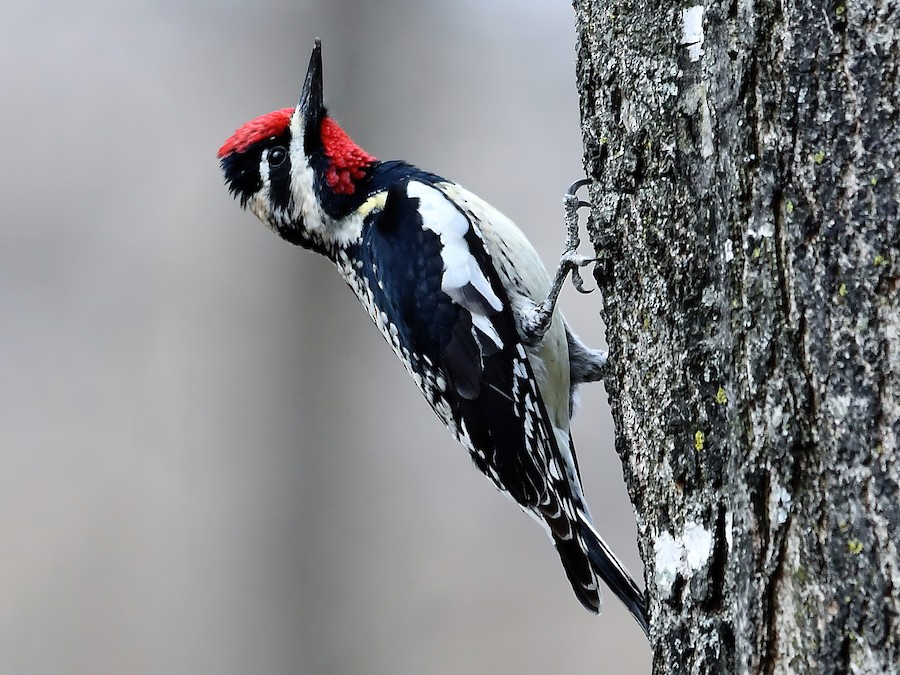
Where to find Yellow-bellied Sapsucker in February
within 25 miles of 35.791540, -78.781117

This page shows which locations in the selected region historically had the highest probability of a checklist including Yellow-bellied Sapsucker in February. Because some locations may be undersampled, the results are sorted based on a confidence score which takes into account how many samples are available. The bar chart shows how the probability of observing this species varies over the year.

Back to the Top Birds list

Rank Map Pics Location Distance Observed Sampled Frequency Confidence
1 Brian P's Yard (Private) 14.4 59 84 70.2% 59.8%
2 stakeout Varied Thrush, Cary (2020) 1.5 44 78 56.4% 45.4%
3 White Pines Nature Preserve 24.5 9 14 64.3% 38.8%
4 Johnston Mill Nature Preserve 20.5 22 43 51.2% 36.8%
5 Lower Haw SNA--Bynum 20.3 9 15 60.0% 35.7%
6 Little Creek Trail 15.3 6 9 66.7% 35.4%
7 Glennstone/Heron Rookery 18.4 7 11 63.6% 35.4%
8 Lake Benson 11.9 64 166 38.6% 31.5%
9 Parker Preserve 15.5 9 17 52.9% 31.0%
10 Horton Grove Nature Preserve 24.6 16 35 45.7% 30.5%
11 Mason Farm Biological Reserve 14.6 131 398 32.9% 28.5%
12 Hank Anderson Community Park 20.3 28 72 38.9% 28.5%
13 Butner Game Land--Brickhouse Rd. (Durham Co.) 21.9 26 67 38.8% 28.0%
14 Eagle Spur Rail Trail--Stagecoach Rd. 11.9 11 24 45.8% 27.9%
15 Wendell Park 22.6 12 27 44.4% 27.6%
16 Ritter Park 4.3 11 25 44.0% 26.7%
17 North Carolina Botanical Garden 16.0 48 147 32.7% 25.6%
18 stakeout Bullock's Oriole, Fuquay-Varina (2024) 14.9 5 10 50.0% 23.7%
19 Flat River Waterfowl Impoundment 23.4 53 180 29.4% 23.3%
20 Brumley Nature Preserve--North 22.2 72 253 28.5% 23.3%
21 Duke University--Wetland Center 'SWAMP' 16.4 20 59 33.9% 23.1%
22 DO NOT USE--Historical Only for Brumley Nature Preserve 22.4 3 5 60.0% 23.1%
23 Briar Chapel--Pokeberry Creek 18.2 34 112 30.4% 22.6%
24 E. Carroll Joyner Park 20.6 8 20 40.0% 21.9%
25 Eno River SP--Few's Ford 23.2 23 74 31.1% 21.7%
26 Homestead Park 19.3 5 11 45.5% 21.3%
27 Neuse River Trail--Abbotts Creek 14.5 43 157 27.4% 21.0%
28 Jordan Lake--Morgan Creek arm (seasonal mudflats) 12.6 2 3 66.7% 20.8%
29 Eno River--Pleasant Green to Cole Mill 21.2 2 3 66.7% 20.8%
30 Butner Game Land--H Street Fields 23.2 2 3 66.7% 20.8%
31 Butner Game Land--Brickhouse Rd. (Granville Co.) 21.9 8 21 38.1% 20.8%
32 Falls Lake--Mountains-to-Sea Trail South of Cheek Rd. 17.4 1 1 100.0% 20.7%
33 Neuse River Trail--Poole Road 14.1 1 1 100.0% 20.7%
34 Cedar Hills Park 9.7 1 1 100.0% 20.7%
35 East Clayton Community Park 23.0 1 1 100.0% 20.7%
36 Mordecai Historic Park 8.2 1 1 100.0% 20.7%
37 White Deer Park 11.6 18 58 31.0% 20.6%
38 Harris Lake County Park 14.0 32 118 27.1% 19.9%
39 Penny's Bend Nature Preserve 20.0 8 22 36.4% 19.7%
40 Crabtree Creek Greenway--Capital Blvd to Atlantic Ave 9.6 3 6 50.0% 18.8%
41 Cape Fear River--Buckhorn Road 20.9 3 6 50.0% 18.8%
42 Neuse River Trail--Mial Plantation Road 18.1 3 6 50.0% 18.8%
43 Jordan Game Land--Lower Little Creek 13.2 3 6 50.0% 18.8%
44 Crabtree Creek Trail--Lindsay Dr. to Bridge by Galax Dr. 5.5 3 6 50.0% 18.8%
45 Old Bynum Bridge 20.4 14 47 29.8% 18.7%
46 Sandy Creek Park 16.1 112 512 21.9% 18.5%
47 Jordan Game Land--Transis Camp Power Line & Trails ONLY 12.4 6 16 37.5% 18.5%
48 Fred Fletcher Park 7.4 26 100 26.0% 18.4%
49 Middle Creek Bottomlands II 24.9 7 20 35.0% 18.1%
50 Duke Forest--Hollow Rock & Hollow Rock Nature Park 17.9 8 24 33.3% 18.0%
51 Southern Community Park--Fan Branch Trail 17.1 8 24 33.3% 18.0%
52 Blackwood Farm Park 22.9 9 28 32.1% 17.9%
53 Lake Lynn 7.7 44 189 23.3% 17.8%
54 Falls Lake--Holly Pt./Shinleaf 15.9 5 13 38.5% 17.7%
55 White Oak Creek Greenway--West Side 6.7 12 41 29.3% 17.6%
56 Third Fork Creek Trail 13.6 17 63 27.0% 17.6%
57 Bond Park 2.7 41 187 21.9% 16.6%
58 Clemmons Educational State Forest 18.0 5 14 35.7% 16.3%
59 Horseshoe Farm Nature Preserve 15.1 13 49 26.5% 16.2%
60 Yates Mill County Park 7.2 106 574 18.5% 15.5%
61 Lake Crabtree County Park 3.6 107 583 18.4% 15.4%
62 Morgan Creek Trail 17.5 12 47 25.5% 15.3%
63 Neuse River Trail--Anderson Point Park 13.5 5 15 33.3% 15.2%
64 Mid Pines Rd. 6.7 127 717 17.7% 15.1%
65 Cedar Falls Park 18.2 2 4 50.0% 15.0%
66 Jordan Game Land--Seaforth Road South End 17.3 2 4 50.0% 15.0%
67 Blue Jay Point County Park 14.5 24 112 21.4% 14.8%
68 North Carolina Museum of Art--Sculpture Garden 4.6 12 49 24.5% 14.6%
69 Turnipseed Preserve 20.5 5 16 31.2% 14.2%
70 Beaver Marsh 16.7 62 355 17.5% 13.9%
71 Jordan Game Land--(751 bridge) White Oak Creek 10.3 4 12 33.3% 13.8%
72 Eastgate Park 9.5 4 12 33.3% 13.8%
73 Clayton Riverwalk--County Line to Sam's Branch Greenway 21.1 4 12 33.3% 13.8%
74 Knap of Reeds Creek Waterfowl Impoundment 23.9 3 8 37.5% 13.7%
75 Shelley Lake 8.1 34 184 18.5% 13.5%
76 Prairie Ridge Ecostation for Wildlife Learning 3.9 80 500 16.0% 13.0%
77 Raven Rock SP 23.9 9 38 23.7% 13.0%
78 Rainbow Soccer Complex 16.2 16 84 19.0% 12.1%
79 Shearon Harris Visitor's Center 12.7 2 5 40.0% 11.8%
80 AIHF Trail 8300 Health Park 10.0 4 14 28.6% 11.7%
81 Jordan Game Land--Transis Camp Rd. 12.6 13 67 19.4% 11.7%
82 Jordan Lake--B. Everett Jordan Dam 18.7 22 128 17.2% 11.6%
83 Schenck Forest 3.6 53 372 14.2% 11.1%
84 Macedonia Lake/Speight Branch Greenway 3.5 7 32 21.9% 11.0%
85 Walnut Creek Wetland Center 9.0 4 15 26.7% 10.9%
86 White Oak Creek Greenway--Wetland 6.1 4 15 26.7% 10.9%
87 Bolin Creek--Umstead Park 18.1 4 15 26.7% 10.9%
88 17 Acre Woods 18.0 8 39 20.5% 10.8%
89 Walnut Creek Trail--Wetland Center 9.0 3 10 30.0% 10.8%
90 Roland E. Horne Walking Trail 23.4 3 10 30.0% 10.8%
91 Crabtree Creek Wetland--West of Raleigh Blvd. 9.8 17 102 16.7% 10.7%
92 Lake Betz 7.3 50 364 13.7% 10.6%
93 Apex Community Park 3.7 32 219 14.6% 10.5%
94 Wilkerson Nature Preserve Park 13.6 7 34 20.6% 10.3%
95 UNC Chapel Hill--Coker Arboretum 17.2 15 91 16.5% 10.3%
96 Barksdale Drive Greenway 9.9 4 16 25.0% 10.2%
97 Lake Johnson Park 4.2 39 287 13.6% 10.1%
98 Bolin Creek--Community Park to MLK Blvd. 17.4 7 36 19.4% 9.8%
99 Falls Lake--Sandling Beach 17.5 2 6 33.3% 9.7%
100 Forest Hills Park 15.0 2 6 33.3% 9.7%
101 Jordan Game Land--Mason Point Peninsula 12.1 5 23 21.7% 9.7%
102 Indian Trail Park 18.1 1 2 50.0% 9.5%
103 Falls Lake--Will Suitt Rd. RR Grade 20.0 1 2 50.0% 9.5%
104 Falls Lake SRA--Woodpecker Ridge 16.3 1 2 50.0% 9.5%
105 Mill Bridge Nature Park 19.4 1 2 50.0% 9.5%
106 Durant Nature Park--Fairy Garden 13.4 1 2 50.0% 9.5%
107 Neuse River Trail--Myakka Court 15.1 1 2 50.0% 9.5%
108 Old Bayleaf Rd (foot access only) 15.2 1 2 50.0% 9.5%
109 Jordan Lake--Parkers Creek (West Side, NCFS Land) 15.4 1 2 50.0% 9.5%
110 American Tobacco Trail--New Hill-Olive Chapel Road Access 10.5 12 76 15.8% 9.3%
111 Piedmont Nature Trail 15.9 4 18 22.2% 9.0%
112 Lower Booker Creek Trail 17.0 6 32 18.8% 8.9%
113 William B. Umstead SP 5.4 5 25 20.0% 8.9%
114 Horace Williams Tract 19.1 5 26 19.2% 8.5%
115 Brumley Nature Preserve--South 22.7 5 26 19.2% 8.5%
116 William B. Umstead SP--Big Lake 5.7 17 129 13.2% 8.4%
117 North Carolina Museum of Life and Science 17.8 6 34 17.6% 8.3%
118 Duke Forest--Gate 12 19.9 2 7 28.6% 8.2%
119 North Carolina Museum of Art--Goodnight Park 4.4 3 13 23.1% 8.2%
120 Eno River SP--Cole Mill/Pump Station 21.6 4 20 20.0% 8.1%
121 Symphony Lake Greenway 4.4 18 155 11.6% 7.5%
122 Bass Lake Park & Trail 10.7 13 104 12.5% 7.5%
123 Historic Oak View Park 11.8 2 8 25.0% 7.1%
124 Jordan Lake--Poe's Ridge 19.9 2 8 25.0% 7.1%
125 Little Creek Waterfowl Impoundment 14.5 4 23 17.4% 7.0%
126 Hilltop Needmore Park--North 11.1 4 23 17.4% 7.0%
127 Forest Ridge Park 16.5 4 24 16.7% 6.7%
128 Jordan Game Land---(751 bridge) Northeast Creek 10.6 3 16 18.8% 6.6%
129 William B. Umstead SP--Reedy Creek Lake 3.8 3 16 18.8% 6.6%
130 Crowder District Park 6.8 4 25 16.0% 6.4%
131 Jordan Lake--Educational State Forest 14.7 6 44 13.6% 6.4%
132 Jordan Game Land--(Big Woods Rd. Bridge) Bush Creek 14.8 2 9 22.2% 6.3%
133 Whippoorwill Park & Warren Creek Trail 19.4 2 9 22.2% 6.3%
134 Beaver Creek Greenway 7.0 2 9 22.2% 6.3%
135 Carroll Howard Johnson Environmental Education Park 15.6 2 9 22.2% 6.3%
136 Laurel Hill Park 5.4 3 17 17.6% 6.2%
137 Lower Haw SNA--Hwy. 64 18.7 1 3 33.3% 6.1%
138 Haw River--Bynum Dam 20.5 1 3 33.3% 6.1%
139 Falls Lake--Olive Grove Church Rd. 17.1 1 3 33.3% 6.1%
140 Duke Forest Rd. 20.7 1 3 33.3% 6.1%
141 Neuse River Trail (Historic only. Use more specific location.) 13.5 1 3 33.3% 6.1%
142 Neuse River Trail--Mingo Bridge 13.6 1 3 33.3% 6.1%
143 Neuse River Trail--Falls River 15.6 1 3 33.3% 6.1%
144 Bethesda Park 11.2 1 3 33.3% 6.1%
145 Hilltop Needmore Park--South 11.5 1 3 33.3% 6.1%
146 Durant Nature Preserve 13.3 11 104 10.6% 6.0%
147 Jordan Lake SRA--Ebenezer Point 15.0 21 235 8.9% 5.9%
148 Falls Lake--Ellerbe Creek RR Grade 19.0 3 18 16.7% 5.8%
149 Merritt's Pasture 16.9 3 18 16.7% 5.8%
150 Lake Raleigh 6.0 19 214 8.9% 5.8%
151 Dorothea Dix 6.6 2 10 20.0% 5.7%
152 Crabtree Creek Watershed 4.7 8 73 11.0% 5.7%
153 Maple View Farm (Birding From Roads Only) 24.1 13 146 8.9% 5.3%
154 Bolin Creek--Adams and Craig Tracts 18.8 2 11 18.2% 5.1%
155 Chapel Hill Community Park 16.9 2 11 18.2% 5.1%
156 Pierce Woods and Pond 15.9 3 21 14.3% 5.0%
157 Jordan Lake SRA--New Hope Overlook 16.7 4 32 12.5% 5.0%
158 Discovery Lake (Restricted Access) 8.2 7 71 9.9% 4.9%
159 Apex Nature Park 8.6 2 12 16.7% 4.7%
160 Falls Lake SRA--Information Center 16.3 1 4 25.0% 4.6%
161 Cornwallis Road Park 16.1 1 4 25.0% 4.6%
162 Eno River SP--Cabe Lands Access 20.8 1 4 25.0% 4.6%
163 Crabtree Creek Greenway--Atlantic Ave to Anderson Drive 8.6 1 4 25.0% 4.6%
164 Horseshoe Road Nature Preserve 22.1 1 4 25.0% 4.6%
165 University Lake, Chapel Hill 19.3 3 23 13.0% 4.5%
166 J.C. Raulston Arboretum 4.6 3 23 13.0% 4.5%
167 Williamson Preserve 19.2 3 23 13.0% 4.5%
168 Sarah P. Duke Gardens 16.8 8 95 8.4% 4.3%
169 Baileywick Road Park 10.2 2 13 15.4% 4.3%
170 Wooten Meadow Park 6.8 2 13 15.4% 4.3%
171 American Tobacco Trail--Southpoint Mall 12.2 2 13 15.4% 4.3%
172 Lake Wheeler 8.2 5 51 9.8% 4.3%
173 Berryhill Park and Trails 18.4 5 52 9.6% 4.2%
174 Duke University--Reclamation Pond 17.3 6 73 8.2% 3.8%
175 South Ellerbe Creek Trail 16.4 3 28 10.7% 3.7%
176 Lake Crabtree Dam 3.3 13 207 6.3% 3.7%
177 Duke Forest--Shepherd Nature Trail 18.7 1 5 20.0% 3.6%
178 Stagecoach Road Waterfowl Impoundment 12.2 1 5 20.0% 3.6%
179 Jordan Lake SRA--Poplar Point 14.2 1 5 20.0% 3.6%
180 Robertson Millpond Preserve 20.7 1 5 20.0% 3.6%
181 Jaycee Park 6.6 1 5 20.0% 3.6%
182 Hemlock Bluffs Nature Preserve 4.6 5 60 8.3% 3.6%
183 Carpenter Park 5.1 3 29 10.3% 3.6%
184 Duke Forest--Korstian Division 19.6 2 16 12.5% 3.5%
185 Jordan Lake--NC Forest HQ (Model Plane Field) 14.1 2 16 12.5% 3.5%
186 Falls Lake--Hickory Hill Boat Ramp 18.4 2 16 12.5% 3.5%
187 Falls Lake--Rolling View 16.1 5 65 7.7% 3.3%
188 New Hope Bottomlands 15.5 1 6 16.7% 3.0%
189 Old Oxford Rd. Pond 20.9 1 6 16.7% 3.0%
190 Falls Lake--Dam 15.2 2 19 10.5% 2.9%
191 UNC Chapel Hill--Battle Park 16.9 2 19 10.5% 2.9%
192 Chandler's Swamp 16.9 2 19 10.5% 2.9%
193 Ammons Farm Rd. 24.7 2 19 10.5% 2.9%
194 Pritchard Park Nature Trail 17.3 3 36 8.3% 2.9%
195 Jordan Game Land--Farrington Point Boating Access 13.1 2 20 10.0% 2.8%
196 Swift Creek Bluffs 5.3 2 20 10.0% 2.8%
197 Town Lake Park 23.4 2 20 10.0% 2.8%
198 Jordan Lake SRA--Seaforth 14.9 7 125 5.6% 2.7%
199 Jordan Lake SRA--Ebenezer Church Boat Ramp 14.8 2 21 9.5% 2.7%
200 Lake Crabtree Nature Trail--Southport Entrance 3.3 8 155 5.2% 2.6%
201 Hoffman Lake 2.4 1 7 14.3% 2.6%
202 Mingo Creek Trail 15.1 1 7 14.3% 2.6%
203 Falls Lake--Mountains-to-Sea Trail Jimmy Rogers Road Access 15.2 1 7 14.3% 2.6%
204 Patterson Place Constructed Wetland 16.0 3 47 6.4% 2.2%
205 Fearrington Village 17.5 2 26 7.7% 2.1%
206 Jordan Lake SRA--Parker's Creek 15.0 2 27 7.4% 2.1%
207 American Tobacco Trail--Olive Chapel Road Access 9.5 2 27 7.4% 2.1%
208 East Fork Mine Creek Trail (Bent Creek) 9.4 1 9 11.1% 2.0%
209 Hymettus Woods Park 5.9 1 9 11.1% 2.0%
210 Dorothea Dix Park 6.9 2 29 6.9% 1.9%
211 New Hope Waterfowl Impoundment 13.8 2 30 6.7% 1.8%
212 Carrboro High School 18.4 1 10 10.0% 1.8%
213 Shiloh Greenway 5.1 1 10 10.0% 1.8%
214 Lake Rogers Park 23.7 1 10 10.0% 1.8%
215 Prairie Ridge Ecostation--Bird Feeders 3.9 3 59 5.1% 1.7%
216 Falls Lake--Hwy. 50 Boat Ramp 16.8 1 11 9.1% 1.6%
217 South Wake County Landfill (Restricted Access) 8.9 1 11 9.1% 1.6%
218 Lake Wheeler marshes 6.9 4 101 4.0% 1.6%
219 North Wake Landfill Park (formerly North Wake Sanitary Landfill) 14.1 2 37 5.4% 1.5%
220 Carolina North--Tripp Farm Gate 19.7 1 12 8.3% 1.5%
221 Walnut Creek Greenway between Lake Dam Rd & Gorman St 5.1 1 12 8.3% 1.5%
222 Brier Creek Reservoir 5.9 6 191 3.1% 1.4%
223 Jordan Lake--New Hope Creek arm (Chatham Co) 12.0 1 14 7.1% 1.3%
224 Downtown Cary Park 0.5 1 14 7.1% 1.3%
225 North Carolina State University Campus 6.2 3 98 3.1% 1.0%
226 Morris Branch Greenway 7.6 1 17 5.9% 1.0%
227 Ten-Ten Road Pond 9.4 1 18 5.6% 1.0%
228 Salem Pond Park 4.5 1 19 5.3% 0.9%
229 Indian Creek Greenway 3.5 1 19 5.3% 0.9%
230 Ephesus Park--Chapel Hill 16.3 1 20 5.0% 0.9%
231 Pullen Park 6.6 1 21 4.8% 0.8%
232 Cedar Fork District Park 3.1 2 67 3.0% 0.8%
233 Jordan Lake--Historical Data Only 15.3 1 22 4.5% 0.8%
234 Harris Lake--NE of New Hill-Holleman Rd. 13.3 1 22 4.5% 0.8%
235 Falls Lake--Beaverdam Reservoir 18.0 1 23 4.3% 0.8%
236 Brookhaven Nature Park 6.7 1 23 4.3% 0.8%
237 Edna Metz Wells Park 7.1 1 25 4.0% 0.7%
238 Harris Game Land--Upper Boat Ramp 15.5 2 110 1.8% 0.5%
239 Jordan Game Land--Audubon Platform 12.3 1 37 2.7% 0.5%
240 NCSU Experimental Farm 7.1 1 38 2.6% 0.5%
241 Inwood Rd. 7.3 1 55 1.8% 0.3%